Gulf of Saint Malo

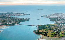
The Gulf of Saint-Malo ( French : Golfe de Saint-Malo ; English : Gulf of Saint-Malo ) is a bay in the southern French part of the English Channel . The town of Saint-Malo at the mouth of the Rance is named for the bay . The gulf is bordered in the south by the coast between Saint-Brieuc and Avranches (with the Côte de Penthièvre in the west and the Côte d'Émeraude - emerald coast - in the middle). In the west, the section from Saint-Brieuc to the Bréhat Islands ( Côte de Goëlo ), which consists mostly of cliffs, borders the Gulf of Saint-Malo. In the east it is the often long sandy beaches of the Cotentin peninsula that limit the gulf. To the north and northwest, the transition to the broad western part of the English Channel and the Atlantic is fluid. The southwest corner of the gulf is called the Bay of Saint-Brieuc ( Baie de Saint-Brieuc ), the southeast corner with the much-visited Abbey of Mont-Saint-Michel is called the Baie du Mont-Saint-Michel . The area of the gulf is about 5000 km² (east-west extension approx. 100 km, north-south extension 45 to 75 km). The coasts of the Gulf of Saint-Malo are heavily stressed by the tides . The tidal range at the Rance tidal power station, the Usine marémotrice de la Rance , between Saint-Malo and Dinard, is more than eight meters high. The shores of the gulf are partly very rugged and have numerous capes and small bays. At low tide, large parts of the bank area dry out, especially in the vicinity of river mouths. Between the towns of Pirou and Saint-Germain-sur-Ay, the Marais du Cotentin et du Bessin Regional Nature Park extends to the coastline.


Islands
The largest and most inhabited islands in the Gulf of Saint-Malo are:
- Jersey , the largest of the Channel Islands
-
Chausey Islands with
- Grande-Île and another 21 small islands
- Mont-Saint-Michel
- Bréhat Islands with the
- Île des Landes
Smaller rock islands
-
Bréhat Islands with
- Île Ar-Morbic
- Île Béniguet
- Île Lavrec
- Île Logodec
- Île Maudez
- Île Raguenez
- Ile Raguenez Meur
- Île Verte
- Roches de Saint-Quay
- Île Agot
- Platier des Lardières
- Le Haumet
- Île de Harbor
- Cezembre
- Le Grand Jardin
- Les Haies de la Conchée
- Les Grands Pointus
- Le Haut Plot
- Le Bénétin
- Rochefort
- Le Grand Chevret
- Les Tintioux (archipelago)
- Herpin
- Île des Rimains
- Le Châtellier
Rivers
The main rivers that flow into the Gulf of Saint-Malo (along the coast from west to east):
Cities and seaside resorts on the Gulf Coast
(along the coast from west to east)
Web links
Coordinates: 49 ° 0 ′ N , 2 ° 15 ′ W


