Gouessant
| Gouessant | ||
|
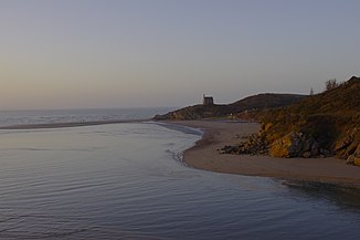
The Anse de Morieux estuary |
||
| Data | ||
| Water code | FR : J13-0300 | |
| location | France , Brittany region | |
| River system | Gouessant | |
| source | west of Collinée 48 ° 18 ′ 23 ″ N , 2 ° 33 ′ 2 ″ W |
|
| Source height | approx. 305 m | |
| muzzle | between Morieux and Hillion in the English Channel Coordinates: 48 ° 31 ′ 36 " N , 2 ° 38 ′ 3" W 48 ° 31 ′ 36 " N , 2 ° 38 ′ 3" W |
|
| Mouth height | 0 m | |
| Height difference | approx. 305 m | |
| Bottom slope | approx. 7.4 ‰ | |
| length | 41 km | |
| Left tributaries | Truite, Evron | |
| Right tributaries | Hia, guest, Chifrouët | |
| Reservoirs flowed through | Barrage Pont-Rolland | |
| Small towns | Lamballe | |
|
Viaduc des Ponts Neufs |
||
The Gouessant is a coastal river in France that runs in the Côtes-d'Armor department in the Brittany region . It rises west of Collinée , at the intersection of the municipalities of Saint-Glen , Trébry and Saint-Gouéno , first drains north-east to north, then turns to north-west and flows 41 kilometers between Morieux and Hillion in the Anse de Morieux , a section of the Baie de Saint-Brieuc in the English Channel . Below Les Pont Neufs , the river forms an estuary , but half of it is flooded by a reservoir on the Barrage Pont-Rolland.
Places on the river
- Saint-Glen
- Noyal
- Lamballe
- Andel
- Les Ponts Neufs , Morieux municipality
Attractions
- Former railway viaduct over the river at Les Ponts Neufs
Individual evidence
- ↑ Source geoportail.gouv.fr
- ↑ estuary geoportail.gouv.fr
- ↑ a b The information on the length of the river is based on the information on the Gouessant at SANDRE (French), accessed on February 22, 2013, rounded to full kilometers.

