
Ile de Bréhat
| Île-de-Bréhat | ||
|---|---|---|

|
|
|
| region | Brittany | |
| Department | Cotes-d'Armor | |
| Arrondissement | Saint-Brieuc | |
| Canton | Paimpol | |
| Coordinates | 48 ° 51 ′ N , 3 ° 0 ′ W | |
| height | 0-34 m | |
| surface | 3.09 km 2 | |
| Residents | 361 (January 1, 2017) | |
| Population density | 117 inhabitants / km 2 | |
| Post Code | 22870 | |
| INSEE code | 22016 | |

The Île de Bréhat (short: Bréhat) is an island in the French department of Côtes-d'Armor on the north coast of Brittany , on the English Channel . The island's Breton name is Enez Vriad . The municipality of Île-de-Bréhat is named after her. The community has 361 inhabitants (as of January 1, 2017).
The Île de Bréhat is the largest island and namesake of the group of Bréhat Islands (French archipelago de Bréhat ).

Île de Bréhat is composed of a north and a south island, which are connected by a bridge, the Pont Vauban . The island is nicknamed L'île des fleurs et des rochers roses (the island of flowers and pink rocks), with the first attribute characterizing the lovelier south island, the second the north island with its striking rocky coast.
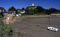
At the northernmost point of the island is the Phare du Paon lighthouse . On the South Island there is the elevated chapel of Saint-Michel (1651) and the port of Port-Clos , to which ferry connections to the mainland lead ( Pointe de l'Arcouest in the municipality of Ploubazlanec ; in the tourist season also to other places). For tourists, boat tours are also offered through the Bréhat archipelago, where the varied coast and the numerous secondary islands can be seen. Cars are forbidden on the island itself (as on the Channel Islands Sark and Herm ), except for the authorities and public services. The island is the site of one of around 100 tidal mills in Brittany that was in operation until 1920.
Population development in the commune of Île-de-Bréhat
| year | 1962 | 1968 | 1975 | 1982 | 1990 | 1999 | 2006 | 2016 |
| Residents | 700 | 653 | 553 | 511 | 461 | 421 | 438 | 364 |
| Sources: Cassini and INSEE | ||||||||

Keranroux Chapel
Saint-Michel chapel
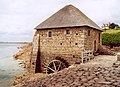
Tide mill Moulin du Birlot

Harbor at low tide


literature
- Le Patrimoine des Communes des Côtes-d'Armor. Flohic Editions, Volume 2, Paris 1998, ISBN 2-84234-017-5 , pp. 775-780.