Merdrignac
| Merdrignac | ||
|---|---|---|

|
|
|
| region | Brittany | |
| Department | Cotes-d'Armor | |
| Arrondissement | Saint-Brieuc | |
| Canton | Broons | |
| Community association | Loudéac Community - Bretagne Center | |
| Coordinates | 48 ° 12 ′ N , 2 ° 25 ′ W | |
| height | 77-196 m | |
| surface | 57.12 km 2 | |
| Residents | 2,930 (January 1, 2017) | |
| Population density | 51 inhabitants / km 2 | |
| Post Code | 22230 | |
| INSEE code | 22147 | |
| Website | http://www.mairie-merdrignac.fr/ | |
Merdrignac ( Breton : Medrineg ) is a French municipality with 2930 inhabitants (as of January 1 2017) in the department of Côtes-d'Armor in the region of Brittany ; it belongs to the arrondissement of Saint-Brieuc and the canton of Broons . The inhabitants are called Merdrignacien (ne) s .
geography
Merdrignac is about 40 kilometers west-northwest of Rennes on the Yvel River . Merdrignac is surrounded by the neighboring communities Mérillac in the north, Saint-Launeuc in the northeast, Trémorel in the east, Illifaut in the southeast, Ménéac in the south and southwest, Gomené in the west, Laurenan in the west and northwest and Saint-Vran in the northwest.
Route nationale 164 and the former route nationale 793 run through the municipality .
Population development
| year | 1962 | 1968 | 1975 | 1982 | 1990 | 1999 | 2006 | 2012 |
| Residents | 2,593 | 2,576 | 2,704 | 2,780 | 2,791 | 2,830 | 2,920 | 2,895 |
Attractions
- Saint-Pierre church
- Sainte-Brigitte chapel from 1872
- La Peignie mansion, built in 1632 on the remains of the old castle from 1204
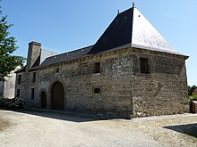
- Le Vieux Bourg manor house from 1644, historic monument since 1990
- Kernué Castle
- La Vallée mansion from 1672
- Town hall from the 19th century
- Cartady wash house
Personalities
- Jacqueline Chevé (1961–2010), politician
literature
- Le Patrimoine des Communes des Côtes-d'Armor. Flohic Editions, Volume 2, Paris 1998, ISBN 2-84234-017-5 , pp. 708-715.
Web links
Commons : Merdrignac - collection of images, videos and audio files

