
Saint-James (Manche)
| Saint-James | ||
|---|---|---|

|
|
|
| region | Normandy | |
| Department | Some | |
| Arrondissement | Avranches | |
| Canton | Saint-Hilaire-du-Harcouët | |
| Community association | Mont-Saint-Michel-Normandy | |
| Coordinates | 48 ° 31 ′ N , 1 ° 19 ′ W | |
| height | 16–151 m | |
| surface | 86.41 km 2 | |
| Residents | 4,954 (January 1, 2017) | |
| Population density | 57 inhabitants / km 2 | |
| Post Code | 50240 | |
| INSEE code | 50487 | |
| Website | http://www.mairie-saintjames.com | |

Saint-James (French pronunciation: [sɛʒɑm]) is a French municipality with 4,954 inhabitants (at January 1, 2017) in the department of Manche in the region of Normandy . It belongs to the Arrondissement of Avranches and the canton of Saint-Hilaire-du-Harcouët .
It was created with effect from January 1, 2017 as the Commune nouvelle of the same name through the amalgamation of the previous municipalities of Saint-James , Argouges , Carnet , La Croix-Avranchin , Montanel , Vergoncey and Villiers-le-Pré , which in the new municipality had the status of a Commune déléguée have. The administrative headquarters are in Saint-James.
structure
| District | former INSEE code |
Area (km²) | Population as of January 1, 2017 |
|---|---|---|---|
| Saint-James (administrative headquarters) | 50487 | 17.96 | 2,779 |
| Argouges | 50018 | 16.41 | 507 |
| Carnet | 50100 | 10.18 | 502 |
| La Croix-Avranchin | 50154 | 10.79 | 445 |
| Montanel | 50337 | 15.40 | 342 |
| Vergoncey | 50627 | 7.73 | 190 |
| Villiers-le-Pré | 50640 | 7.94 | 189 |
location
Saint-James is on the border between Normandy and Brittany , near Mont-Saint-Michel , on the banks of the Beuvron River . The Guerge also crosses the municipality.
politics
Town twinning
Saint James maintains a following two municipalities twinning .
- In Germany with Erkelenz in North Rhine-Westphalia , the friendship certificate was sealed on October 12, 1974.
- In Great Britain with Beaminster ( South West England ) since 1978.
Attractions

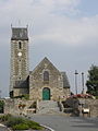
The Church of St. James

The former Mairie of Argouges
The Saint-Pierre church in Argouges

_Mairie.jpg)
_%C3%89glise_01.jpg)
- The grooves of the megalithic culture of Saint-Benoît, recognized as a Monument Historique .
- The 13th century cemetery gate
- The 13th century church of Saint-Jacques with a triforium and a Romanesque portal. In the church there is a Madonna and Child from the 14th century .
- The 14th century church of Saint-Benoît .
- The 15th century castle of Paluelle and its park are classified as a monument .
- Traces of the former Saint-James castle can be found in the place la Haye de Terre .
The American War Cemetery
The American military cemetery ( World War II Brittany American Cemetery and Memorial ) is 2.4 kilometers southeast of Saint-James. 4410 American soldiers were buried here. The names of 498 missing persons can be read on one wall. The cemetery has an area of 28 acres (11.3 hectares ).
Economy and Infrastructure
- The textile company Tricots Saint James , founded in 1850/1889, uses wool and cotton to produce high-quality clothing , knitwear and t-shirts in sailor style . In 2012 it employed 300 people.
traffic
- The A84 autoroute from Caen to Rennes passes Saint-James to the west.
literature
- Maria Meurer (adaptation): 40 years of town twinning 40 Éme Anniversaire Du Jumelage Saint James & Erkelenz, Erkelenz 2014, (German-French brochure)
Web links
- The official website of the St. James Ward
- Saint James jerseys
- The official website of the American War Cemetery
- Find a grave in the American War Cemetery
Individual evidence
- ↑ Decree of the Prefecture No. 124 on the formation of the Saint-James nouvelle commune of 8 July 2016.
- ↑ current population according to INSEE
- ↑ http://www.wikimanche.fr/Tricots_Saint-James