
Saint-Jean-des-Champs
| Saint-Jean-des-Champs | ||
|---|---|---|
|
||
| region | Normandy | |
| Department | Some | |
| Arrondissement | Avranches | |
| Canton | Bréhal | |
| Community association | Granville, Terre et Mer | |
| Coordinates | 48 ° 50 ′ N , 1 ° 28 ′ W | |
| height | 21-122 m | |
| surface | 19.4 km 2 | |
| Residents | 1,410 (January 1, 2017) | |
| Population density | 73 inhabitants / km 2 | |
| Post Code | 50320 | |
| INSEE code | 50493 | |
.jpg) Town hall (Mairie) of Saint-Jean-des-Champs |
||

Saint-Jean-des-Champs is a French commune with a population of 1,410 (as at 1st January 2017) in the department of Manche in the region of Normandy . It belongs to the Arrondissement of Avranches and the Canton of Bréhal (until 2015: Canton of La Haye-Pesnel ). The inhabitants are called Saint-Jeanais .
geography
Saint-Jean-des-Champs is about nine kilometers west of Granville . Saint-Jean-des-Champs is surrounded by the neighboring municipalities of Hudimesnil in the north, Saint-Sauveur-la-Pommeraye in the northeast, Folligny in the east, La Lucerne-d'Outremer in the south and southeast, and Saint-Pierre-Langers in the south and southwest , Saint-Aubin-des-Préaux in the southwest, Saint-Planchers in the west and Coudeville-sur-Mer in the northwest.
history
In 1973, the previously independent municipalities of Saint-Léger and Saint-Ursin were incorporated into the municipality.
Population development
| year | 1962 | 1968 | 1975 | 1982 | 1990 | 1999 | 2006 | 2013 |
| Residents | 594 | 545 | 800 | 873 | 989 | 1116 | 1259 | 1361 |
| Source: Cassini and INSEE | ||||||||
Attractions
- Saint-Léger church from the 12th century, monument historique
- 19th century Saint-Jean church, rebuilt after a fire in 1869
- Saint-Ursin church, 12th century portal
- Le Pont-Roger castle with chapel. Monument historique
- L'Hermetière manor
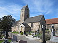
Saint-Léger church

Saint-Jean church

Saint-Ursin Church


.JPG)
Parish partnership
A partnership has existed with the Swiss municipality of Val-d'Illiez in the canton of Valais since 1993.
Personalities
- Paul Decauville (1846–1922), industrialist and politician (Mayor of Saint-Léger)