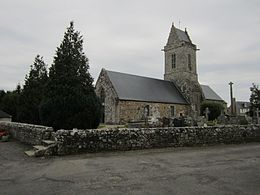
Saint-Aubin-des-Préaux
| Saint-Aubin-des-Préaux | ||
|---|---|---|
|
|
||
| region | Normandy | |
| Department | Some | |
| Arrondissement | Avranches | |
| Canton | Bréhal | |
| Community association | Granville, Terre et Mer | |
| Coordinates | 48 ° 48 ′ N , 1 ° 30 ′ W | |
| height | 11-94 m | |
| surface | 8.24 km 2 | |
| Residents | 438 (January 1, 2017) | |
| Population density | 53 inhabitants / km 2 | |
| Post Code | 50380 | |
| INSEE code | 50447 | |
| Website | http://saint-aubin-des-preaux.fr/ | |
 Town hall (Mairie) of Saint-Aubin-des-Préaux |
||
Saint-Aubin-des-Préaux is a French municipality with 438 inhabitants (as of January 1 2017) in the department of Manche in the region of Normandy . It belongs to the Arrondissement of Avranches and the Canton of Bréhal (until 2015: Canton Granville ). The inhabitants are called Saint-Aubinais .
geography
Saint-Aubin-des-Préaux is about seven kilometers south-east of Granville , a small coastal town on the Gulf of Saint-Malo , a few kilometers north of Mont-Saint-Michel . The municipality is surrounded by the neighboring municipalities of Saint-Planchers in the north, Saint-Jean-des-Champs in the east, Saint-Pierre-Langers in the south and Saint-Pair-sur-Mer in the west.
Population development
| year | 1962 | 1968 | 1975 | 1982 | 1990 | 1999 | 2006 | 2013 |
| Residents | 279 | 274 | 268 | 314 | 339 | 379 | 404 | 423 |
| Source: Cassini and INSEE | ||||||||
Attractions
- Romanesque church of Saint-Aubin from the 12th century, Monument historique
Web links
Commons : Saint-Aubin-des-Préaux - Collection of images, videos and audio files

