Hudimesnil
| Hudimesnil | ||
|---|---|---|
|
|
||
| region | Normandy | |
| Department | Some | |
| Arrondissement | Avranches | |
| Canton | Bréhal | |
| Community association | Granville, Terre et Mer | |
| Coordinates | 48 ° 52 ′ N , 1 ° 30 ′ W | |
| height | 28-117 m | |
| surface | 18.68 km 2 | |
| Residents | 900 (January 1, 2017) | |
| Population density | 48 inhabitants / km 2 | |
| Post Code | 50510 | |
| INSEE code | 50252 | |
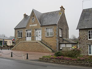
 City Hall (Mairie) of Hudimesnil |
||
Hudimesnil is a commune in the Manche department in the region of Normandy in France with 900 inhabitants (as of January 1, 2017). Hudimesnil is part of the Avranches arrondissement and the Bréhal canton . The inhabitants are called Hudimesnillais .
geography
Hudimesnil is located in the south of the Cotentin peninsula on the Boscq river . Hudimesnil is surrounded by the neighboring communities of Chanteloup in the north and northwest, Cérences in the north and northeast, Le Loreur in the east, Saint-Sauveur-la-Pommeraye in the southeast, Saint-Jean-des-Champs in the south and Coudeville-sur-Mer in the west .
Population development
| 1962 | 1968 | 1975 | 1982 | 1990 | 1999 | 2006 | 2012 |
|---|---|---|---|---|---|---|---|
| 685 | 647 | 581 | 510 | 614 | 716 | 814 | 862 |
| Source: Cassini and INSEE | |||||||
Attractions
- Notre-Dame Church, rebuilt in 1837
- Ruins of the Sainte-Suzanne chapel
- Watermill on Boscq
Personalities
- Geneviève Gambillon (* 1951), former cyclist
Parish partnership
There is a partnership with the British parish of Thornford in Dorset (England).
Web links
Commons : Hudimesnil - collection of pictures, videos and audio files


