
Saint-Cyr-du-Bailleul
| Saint-Cyr-du-Bailleul | ||
|---|---|---|
|
||
| region | Normandy | |
| Department | Some | |
| Arrondissement | Avranches | |
| Canton | Le Mortainais | |
| Community association | Mont-Saint-Michel-Normandy | |
| Coordinates | 48 ° 34 ′ N , 0 ° 48 ′ W | |
| height | 92-226 m | |
| surface | 23.41 km 2 | |
| Residents | 399 (January 1, 2017) | |
| Population density | 17 inhabitants / km 2 | |
| Post Code | 50720 | |
| INSEE code | 50462 | |
| Website | http://www.saint-georges-de-rouelley.a3w.fr | |
 Town hall (Mairie) of Saint-Cyr-du-Bailleul |
||

Saint-Cyr-du-Bailleul is a French municipality with 399 inhabitants (as of January 1 2017) in the department of Manche in the region of Normandy . The municipality belongs to the Arrondissement of Avranches and the canton of Le Mortainais (until 2015: canton of Barenton ). The inhabitants are called Saint-Cyriens .
geography
Saint-Cyr-du-Bailleul is located about 50 kilometers east-southeast of the city center of Avranches . The parish is part of the Normandy-Maine Regional Nature Park . Saint-Cyr-du-Bailleul is surrounded by the neighboring communities of Barenton in the north, Saint-Georges-de-Rouelley in the northeast, Saint-Roch-sur-Égrenne in the east, Saint-Mars-d'Égrenne in the southeast, and Mantilly in the south Le Teilleul to the southwest and west.
Population development
| year | 1962 | 1968 | 1975 | 1982 | 1990 | 1999 | 2006 | 2013 |
| Residents | 858 | 699 | 660 | 625 | 490 | 444 | 428 | 401 |
| Source: Cassini and INSEE | ||||||||
Attractions
- Menhir Pierre Saint-Martin
- Saint-Cyr-et-Sainte-Julitte church
- Chapel of Le Jarry
- Le Bailleul Castle
- La Motte Castle

Menhir Saint-Pierre
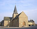
Saint-Cyr-et-Sainte-Julitte church

Le Bailleul Castle

Chapel of Le Jarry
.JPG)


