
Tirepied-sur-Sée
| Tirepied-sur-Sée | ||
|---|---|---|
|
||
| region | Normandy | |
| Department | Some | |
| Arrondissement | Avranches | |
| Canton | Isigny-le-Buat | |
| Community association | Communauté d'agglomération Mont-Saint-Michel-Normandie | |
| Coordinates | 48 ° 43 ′ N , 1 ° 16 ′ W | |
| height | 8-149 m | |
| surface | 22.55 km 2 | |
| Residents | 947 (January 1, 2017) | |
| Population density | 42 inhabitants / km 2 | |
| Post Code | 50450 | |
| INSEE code | 50597 | |

Tirepied-sur-Sée is a French municipality with 947 inhabitants (at January 1, 2017) in the Manche department in the region of Normandy . It belongs to the Arrondissement of Avranches and the canton of Isigny-le-Buat .
It was created with effect from January 1, 2019 as Commune nouvelle by merging the previous municipalities of Tirepied and La Gohannière , which were not granted the status of a Commune déléguée in the new municipality . The administrative seat is in Tirepied.
structure
| District | former INSEE code |
Area (km²) | Population (2016) |
|---|---|---|---|
| La Gohannière | 50206 | 3.78 | 118 |
| Tirepied (administrative headquarters) | 50597 | 18.77 | 818 |
location
Neighboring municipalities are Le Parc in the northwest, La Chaise-Baudouin in the north, Saint-Georges-de-Livoye in the northeast, Vernix in the east, Le Petit-Celland and Saint-Ovin in the southeast, La Godefroy in the south, Saint-Brice and Saint- Senier-sous-Avranches to the southwest and Ponts to the west. The name affix testifies to the Sée river that flows past La Gohannière.

The lake at La Gohannière

Entrance to the village of La Gohannière
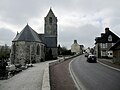
Tirepied


.JPG)
Web links
Individual evidence
- ↑ Decree of the Prefecture No. 18-56 on the formation of the Commune nouvelle Tirepied-sur-Sée of September 27, 2018.
- ↑ Population figures retrospectively from January 1, 2016