
Tirepied
| Tirepied | ||
|---|---|---|
|
||
| local community | Tirepied-sur-Sée | |
| region | Normandy | |
| Department | Some | |
| Arrondissement | Avranches | |
| Coordinates | 48 ° 43 ′ N , 1 ° 16 ′ W | |
| Post Code | 50870 | |
| Former INSEE code | 50597 | |
| Incorporation | 1st January 2019 | |

Tirepied is a village and a former municipality last 818 inhabitants (at January 1, 2016) in the French department Manche in the region of Normandy . The previously independent municipality was merged with La Gohannière to form Commune nouvelle Tirepied-sur-Sée with effect from January 1, 2019 . The former municipalities were not granted the status of a Commune déléguée in the new municipality . The administrative seat is in Tirepied.
location
Neighboring towns are Plomb in the north-west, Braffais in the north, La Chaise-Baudouin and Saint-Georges-de-Livoye in the north-east, Vernix and La Gohannière in the south-east, Saint-Brice in the south, Saint-Senier-sous-Avranches in the south-west and Ponts in the West.
Population development
| year | 1962 | 1968 | 1975 | 1982 | 1990 | 1999 | 2008 | 2015 |
|---|---|---|---|---|---|---|---|---|
| Residents | 713 | 668 | 626 | 643 | 638 | 693 | 770 | 802 |
Attractions
- Notre-Dame church
- Church of Sainte-Eugienne

Notre-Dame church
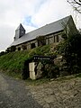
Church of Sainte-Eugienne

.JPG)