
Tinchebray bocage
| Tinchebray bocage | ||
|---|---|---|
.svg)
|
|
|
| region | Normandy | |
| Department | Orne | |
| Arrondissement | Argentan | |
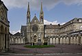
| Canton | Cathedral front | |
| Community association | Domfront Tinchebray Interco | |
| Coordinates | 48 ° 46 ′ N , 0 ° 44 ′ W | |
| height | 77-151 m | |
| surface | 99.88 km 2 | |
| Residents | 4,933 (January 1, 2017) | |
| Population density | 49 inhabitants / km 2 | |
| Post Code | 61800 | |
| INSEE code | 61486 | |
| Website | http://www.tinchebray.fr/ | |
 Tinchebray Town Hall |
||

Tinchebray-Bocage is a French commune with 4,933 inhabitants (as of January 1 2017) in the department of Orne in the region of Normandy . It is a so-called Commune nouvelle , which was created on January 1, 2015 through the merger of the formerly independent municipalities of Beauchêne , Frênes , Larchamp , Saint-Cornier-des-Landes , Saint-Jean-des-Bois , Tinchebray and Yvrandes . It belongs to the Arrondissement of Argentan and the canton of Domfront .
geography

The Noireau flows through the municipality . Tinchebray-Bocage is surrounded by the neighboring communities of Saint-Quentin-les-Chardonnets in the north, Montsecret-Clairefougère in the northeast, Cerisy-Belle-Étoile in the east and northeast, Landisacq and Chanu in the east, Saint-Clair-de-Halouze and Saint- Bômer-les-Forges in the south-east, Lonlay-l'Abbaye in the south, Ger in the south-west, Le Fresne-Poret and Saint-Christophe-de-Chaulieu in the west and Le Ménil-Ciboult in the north-west.
The former Routes nationales 24bis (today's D924) and 811 (today's D911) run through the municipality .
history
In 1106 there was an armed conflict between Normandy and England at Tinchebray. Normandy wanted independence. As a result of their defeat in this battle of Tinchebray , the unity between Normandy and the Kingdom of England finally solidified. In 1204, Normandy was "confiscated" by France, and the rule of Tinchebray was declared a crown domain in 1259 . The municipality was formed on January 1, 2015 from the municipalities of Tinchebray , Beauchêne , Frênes , Larchamp , Saint-Cornier-des-Landes , Saint-Jean-des-Bois and Yvrandes .
Population development
Tinchebray only
| year | 1962 | 1968 | 1975 | 1982 | 1990 | 1999 | 2006 | 2012 |
| Residents | 3,019 | 3,045 | 3,205 | 3,202 | 2,955 | 2,891 | 2,681 | 2,642 |
Personalities
- Wilhelm (died 1140), nephew of Wilhelm the Conqueror
- Jean-Baptiste Quéruel (1779–1845), chemist,
- André Breton (1896–1966), writer
Attractions
Tinchebray
- Saint-Pierre-et-Saint-Paul church from 1830
- Sainte-Marie church from 1860
- Notre-Dame-des-Montiers church, late 15th century, rebuilt in 17th century, Monument historique cemetery
- Saint-Rémy church
- Chapel Les Genestés or Chapel Sainte-Anne, largely destroyed
- former royal prison
- Wash house
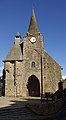
Saint-Rémy church

Saint-Pierre-et-Saint-Paul church
Sainte-Marie church

Notre-Dame des Montiers church

former prison


Beauchêne
- Notre-Dame-de-la-Paix Sainte-Pierre-et-Saint-Paul church from 1900
- Wash house
Frênes
- Notre-Dame church from the 19th century with bell tower from the 17th century
- protestant church
- Frichetière manor
- Wash house

Notre-Dame church in Frênes

Larchamp
- Notre-Dame church from the 19th century
- Wash houses
Saint-Jean-des-Bois
- Saint-Jean-Baptiste church from the 19th century
- La Guyonnière mansion, historic monument
Saint-Cornier-des-Landes
- 19th century church

Church in Saint-Cornier-des-Landes

Yvrandes
- Notre-Dame church from the 14th century, monument historique
- Remains of the old priory from the 12th century

Notre-Dame church in Yvrandes

Parish partnership
The municipality of Saint-Cornier-des-Landes has had a partnership with the French municipality of Viry in the Jura department since 1988 .