Noireau
| Noireau | ||
| Data | ||
| Water code | FR : I24-0400 | |
| location | France , Normandy region | |
| River system | Orne | |
| Drain over | Orne → English Channel | |
| source | in the municipality of Saint-Christophe-de-Chaulieu, 48 ° 45 ′ 19 ″ N , 0 ° 48 ′ 50 ″ W |
|
| Source height | approx. 290 m | |
| muzzle | near Pont-d'Ouilly , on the municipal border with Ménil-Hubert-sur-Orne in the Orne Coordinates: 48 ° 52 ′ 17 " N , 0 ° 24 ′ 35" W 48 ° 52 ′ 17 " N , 0 ° 24 ′ 35 ″ W. |
|
| Mouth height | approx. 46 m | |
| Height difference | approx. 244 m | |
| Bottom slope | approx. 5.7 ‰ | |
| length | 43 km | |
| Catchment area | 528 km² | |
| Discharge at the gauge Cahan A Eo : 520 km² |
MQ Mq |
7.3 m³ / s 14 l / (s km²) |
| Left tributaries | Diane , Druance | |
| Right tributaries | Vère | |
| Small towns | Condé-sur-Noireau | |
|
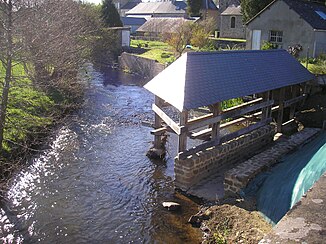
The river at Montsecret |
||
The Noireau is a river in France that runs in the Normandy region . It rises in the municipality of Saint-Christophe-de-Chaulieu , generally drains north-east and flows into the Orne after 43 kilometers at Pont-d'Ouilly , on the municipal border with Ménil-Hubert-sur-Orne as a left tributary . On its way, the Noireau first crosses the Orne department , reaches the neighboring Calvados department at Condé-sur-Noireau and follows the border line to its mouth.
Places on the river
(Order in flow direction)
- Tinchebray
- Montsecret , municipality of Montsecret-Clairefougère
- Cerisy-Belle-Étoile
- Saint-Pierre-du-Regard
- Condé-sur-Noireau
- Pont-d'Ouilly
Web links
Commons : Noireau - collection of images, videos and audio files
Individual evidence
- ↑ Source geoportail.fr (1: 16,000)
- ↑ estuary geoportail.fr (1: 16,000)
- ↑ a b c The information on the length of the river is based on the information about the Noireau at SANDRE (French), accessed on August 29, 2011, rounded to full kilometers.
- ↑ hydro.eaufrance.fr (station: I3462010 , option: Synthèse )

