Craménil
| Craménil | ||
|---|---|---|
|
|
||
| region | Normandy | |
| Department | Orne | |
| Arrondissement | Argentan | |
| Canton | Athis-de-l'Orne | |
| Community association | Communauté de communes du Val d'Orne | |
| Coordinates | 48 ° 45 ′ N , 0 ° 23 ′ W | |
| height | 174-253 m | |
| surface | 8.09 km 2 | |
| Residents | 148 (January 1, 2017) | |
| Population density | 18 inhabitants / km 2 | |
| Post Code | 61220 | |
| INSEE code | 61137 | |
Craménil is a French commune with 148 inhabitants (as of January 1, 2017) in the Orne department in the Normandy region (before 2016 Basse-Normandie ). It belongs to the Arrondissement of Argentan and the canton of Athis-de-l'Orne ( Briouze until 2015 ). The inhabitants are called Craménilois .
geography
Craménil is about 29 kilometers west-southwest of the city center of Argentan . Craménil is surrounded by the neighboring communities of Sainte-Honorine-la-Guillaume in the north, Putanges-le-Lac in the northeast, Saint-André-de-Briouze in the east and south-east, Briouze in the south, Sainte-Opportune in the west and Les Tourailles in the north-west .
Population development
| 1962 | 1968 | 1975 | 1982 | 1990 | 1999 | 2006 | 2011 | 2016 |
|---|---|---|---|---|---|---|---|---|
| 191 | 168 | 172 | 187 | 155 | 156 | 161 | 165 | 156 |
| Source: Cassini and INSEE | ||||||||
Attractions
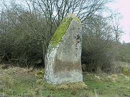
- The Menhir Affiloir de Gargantua , Monument historique since 1889
- Saint-Laurent Church, built in 1911
Individual evidence
Web links
Commons : Craménil - collection of images, videos and audio files

