
Montreuil-la-Cambe
| Montreuil-la-Cambe | ||
|---|---|---|
|
||
| region | Normandy | |
| Department | Orne | |
| Arrondissement | Argentan | |
| Canton | Argentan-2 | |
| Community association | Argentan Intercom | |
| Coordinates | 48 ° 53 ' N , 0 ° 3' E | |
| height | 74-260 m | |
| surface | 9.57 km 2 | |
| Residents | 70 (January 1, 2017) | |
| Population density | 7 inhabitants / km 2 | |
| Post Code | 61160 | |
| INSEE code | 61291 | |

Montreuil-la-Cambe is a French commune with 70 inhabitants (as of January 1, 2017) in the Orne department in the Normandy region (before 2016 Basse-Normandie ). It belongs to the Arrondissement of Argentan and the Canton of Argentan-2 ( Trun until 2015 ). The inhabitants are called Montreuillais .
geography
Montreuil-la-Cambe is located about 20 kilometers north-northeast of the city center of Argentan . Montreuil-la-Cambe is surrounded by the neighboring communities of Les Moutiers-en-Auge in the north and northwest, Saint-Gervais-des-Sablons in the north and northeast, Écorches in the east, Trun and Louvières-en-Auge in the south, Fontaine-les -Bassets to the south and southwest and Le Marais-la-Chapelle to the west.
Population development
| 1962 | 1968 | 1975 | 1982 | 1990 | 1999 | 2006 | 2011 | 2016 |
|---|---|---|---|---|---|---|---|---|
| 148 | 138 | 103 | 94 | 84 | 79 | 83 | 81 | 72 |
| Source: Cassini and INSEE | ||||||||
Attractions
- Saint-Aubin church in Montreuil-Beauvais from the 15th century
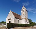
- Saint-Michel church in La Cambe from the 11th century
- Eighteenth-century rectory in Montreuil
- 18th century rectory of La Cambe
- Beauvais Castle from the 16th century
Saint-Aubin church

Saint-Michel church

