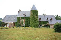
Saint-Bômer-les-Forges
| Saint-Bômer-les-Forges | ||
|---|---|---|
|
|
||
| region | Normandy | |
| Department | Orne | |
| Arrondissement | Argentan | |
| Canton | Cathedral front | |
| Community association | Domfront Tinchebray Interco | |
| Coordinates | 48 ° 39 ′ N , 0 ° 38 ′ W | |
| height | 137-271 m | |
| surface | 31.08 km 2 | |
| Residents | 1,040 (January 1, 2017) | |
| Population density | 33 inhabitants / km 2 | |
| Post Code | 61700 | |
| INSEE code | 61369 | |
| Website | http://www.saint-bomer-les-forges.fr/ | |
Saint-Bômer-les-Forges is a French commune with 1,040 inhabitants (as of January 1 2017) in the department of Orne in the region of Normandy . It belongs to the Argentan arrondissement and is part of the canton of Domfront . The inhabitants are called Bohamadiens .
geography
Saint-Bômer-les-Forges is about 58 kilometers west-northwest of Alençon . The parish is part of the Normandy-Maine Regional Nature Park . Saint-Bômer-les-Forges is surrounded by the neighboring communities of Saint-Clair-de-Halouze in the north, Le Châtellier in the north-east, Banvou in the east and north-east, Dompierre in the east, Champsecret in the east and south-east, Domfront en Poiraie in the south and south-west , Lonlay-l'Abbaye in the west and Tinchebray-Bocage in the northwest.
Population development
| year | 1962 | 1968 | 1975 | 1982 | 1990 | 1999 | 2006 | 2013 |
| Residents | 1,123 | 1,075 | 968 | 983 | 875 | 854 | 977 | 1,037 |
| Source: Cassini and INSEE | ||||||||
Attractions
- Dolmen of Le Creux and Le Mégraire, each monument historique
- Saint-Bômer church
- Manor of La Nocherie
- Manor of La Béradière
- Manor house of La Maigraire
- Montpatry mansion
- Remains of Jumilly Castle

