
Cap Gris-Nez
Coordinates: 50 ° 52 ′ 15 ″ N , 1 ° 35 ′ 1 ″ E

The Cap Gris-Nez ( gris-nez , Dutch Swartenesse , dt. "Gray nose" ) is a headland on the French Channel coast, the Côte d'Opale , in the Hauts-de-France region in northern France. It is located between Calais and Boulogne-sur-Mer . The term "gray" arose because the exposed rock is gray, in contrast to the Cap Blanc-Nez , which is in sight to the north , where the bright white chalk rock comes to light .
There is a lighthouse on the summit of Cap Gris-Nez ( 50 m ) . From here, all shipping traffic on the English Channel is monitored from the French side.
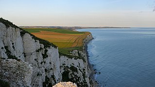
The line of sight from Cap Gris-Nez to Shakespeare Cliff near Dover forms the point at which the island of Great Britain and continental Europe are closest, only 33 km away; this narrowest section of the canal has its own name, the Strait of Dover . From Cap Gris-Nez you can see as far as England on a clear day ; if you look south along the coast, you can see the port of Boulogne-sur-Mer.
history
This stretch of coast was liberated by Canadian troops during the Second World War in the course of Operation Overlord and Operation Undergo . The area around Cap Gris-Nez still shows visible traces of the heavy bombing raids against this part of the “ Atlantic Wall ” in 1944. The former German fort and the Battery Todt gun emplacement are located in the same section .
The German writer and later winner of the Nobel Prize for Literature, Heinrich Böll, was also stationed at Cap Gris-Nez as a soldier during World War II.

Cap Gris-Nez (west side)
View from Cap Blanc-Nez to Cap Gris-Nez over the Bay of Wissant

View of the White Cliffs of Dover from Cap Gris-Nez
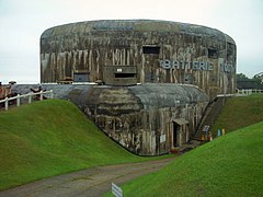
German fort near Cap Gris-Nez, June 10, 2004


literature
- Heinrich Böll: letters from the war. 1939-1945 . Kiepenheuer & Witsch, Cologne 2001.