
Cap Blanc-Nez
Coordinates: 50 ° 55 ′ 30.2 " N , 1 ° 42 ′ 33.8" E

The Cap Blanc-Nez ( Blanc-Nez "white nose") ( Dutch Blank Esse ) is a headland at France sleeves Channel coast, which in this area d'Côte Opale is called, in the region of Hauts-de-France in northern France. It is located south of Calais . Together with Cap Gris-Nez , it forms the "area of the two capes" ( Site de deux Caps ), which is closed in the south of Boulogne-sur-Mer .
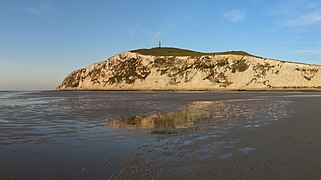
The Cap Blanc-Nez consists of chalk rock and marl and has steeply sloping sides to the sea. On the summit ( 132 m ) there are bunkers from the Second World War and an obelisk. The obelisk was erected in honor of the British Dover Patrol of the First World War. The bunker system was built by the occupying forces of the National Socialist German Reich and is part of a complex with the “Würzburg Riese” radar system and the “Lindenmann battery” in neighboring Sangatte . The traces of the fighting of the Second World War at this strategically extremely important place can also be recognized by the numerous and still clearly visible bomb craters. On a clear day, the Chalk Cliffs of Dover can be clearly seen across the Strait of Dover , Cap Gris-Nez, and Wissant Bay to the south.
Renaturation of the Cape tip
Thanks to the crevices and small caves in the chalky wall, the rocks represent an important nest building site for many birds such as jackdaws , house martins , fulmars , kestrels , gulls , terns and herring gulls . As part of a renaturation project, part of the asphalt road leading to the summit was built in 2006 and completely dismantled the parking spaces available there. For this purpose, a parking lot located approx. 300 meters inland was significantly enlarged.
View from the stand
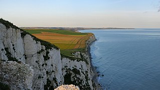
View from Cap Blanc-Nez to Cap Gris-Nez over the Bay of Wissant

View from the east. To the right behind the chalk cliffs of Dover


