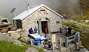
Capanna Albagno
| Capanna Albagno UTOE hut |
||
|---|---|---|
| location | Valle di Gorduno; Canton Ticino , Switzerland ; Valley location: Gorduno , Bellinzona | |
| Mountain range | Lepontine Alps | |
| Geographical location: | 717.1 thousand / 120137 | |
| Altitude | 1870 m above sea level M. | |
|
|
||
| owner | Bellinzona section of the UTOE | |
| Built | 1932, 2005 | |
| Construction type | hut | |
| Usual opening times | Opened all year round, May to October | |
| accommodation | 28 beds, 0 camps | |
| Winter room | 26 bearings | |
| Hut directory | SAC | |
The Capanna Albagno ( German Albagnohütte ) is a refuge in Valle di Gorduno in the district Gorduno the community Bellinzona in canton Ticino in the Lepontine Alps at an altitude of 1870 m above sea level. M.
History and description
The two-story stone hut was inaugurated in 1932 and renovated in 2005. It is located on the mountain range that separates the Gorduno and Sementina valleys. It belongs to the Bellinzona section of the Unione Ticinese Operai Escursionisti (UTOE) under the umbrella organization Federazione Alpinistica Ticinese (FAT).
The hut has a lounge / dining room with 28 seats. The 28 beds are divided into two rooms with 6, 6, and 16 beds each. The kitchen has a gas and wood stove. It is heated with wood and illuminated with solar cells. There is an outside terrace with tables. It is open all year round with cooking facilities, but only temporarily manned from June to October. Access in winter is not recommended due to the steep slopes being traversed.
The area is suitable for hikers and families and as a starting point for the transition to other huts in the region.
The hut is the stage of the eleventh stage of the Via Alta Idra high-altitude trail , which leads in 12 stages from the source of the Ticino river to its confluence with Lake Maggiore .
Hut access with walking time
- From Mornera ( 1083 m above sea level ) in 1 ¾ hours (level of difficulty T2). A cable car leads from Monte Carasso to Mornera.
- From Monti di Bedretto ( 1283 m above sea level ) above Gorduno in 2 hours (T2). The Monti di Bedretto can be reached by car.
Ascents
- Bocchetta d'Albagno ( 2057 m above sea level ) in 20 minutes (T3)
- Gaggio ( 2267 m above sea level ) in 1 ¼ hours (T3)
- Cima dell'Uomo ( 2390 m above sea level ) in 2 ½ hours (T4)
- Cima di Morisciolo ( 2201 m above sea level ) in 3 hours (T3)
- Cima d'Erbea ( 2338 m above sea level ) in 1 ½ hours (T4)
- Madone ( 2395 m above sea level ) in 3 ½ hours (T3)
- Pizzo di Vogorno ( 2442 m above sea level ) in 6 hours (T3)
- Via Alta della Verzasca is a “white-blue-white” marked route (T4 to T6) for experienced mountain hikers in four stages.
Via ferrata
- The "Tresignori" via ferrata is 20 minutes from Mornera.
Transitions to neighboring huts
- Capanna Mognone ( 1463 m above sea level )
- Capanna Orino ( 1395 m above sea level )
- Capanna Gariss ( 1422 m above sea level ) via Bocchetta d'Albagno ( 2057 m above sea level )
- Capanna Borgna via Bocchetta d'Erbea ( 2251 m above sea level ) and Bocchetta della Cima dell'Uomo ( 2278 m above sea level ) and Passo di Ruscada ( 2071 m above sea level )
- Capanna Alpe Lèis via Bocchetta della Cima dell'Uomo and Bocchetta Cazzane ( 2104 m above sea level )
- Capanna Fümegna , Val Pincascia, Lavertezzo, ( 1810 m above sea level ) in 6 hours
literature
- Massimo Gabuzzi: Huts and rifugi in Ticino and Misox . Edizioni Salvioni, Bellinzona 2005, ISBN 978-88-7967-123-1
Web links
- Homepage of the Capanna Albagno
- Ticino huts: Albagno, Bellinzonese, Valle di Gorduno
- SAC: Capanna Albagno

