Capanna Tamaro
| Capanna Tamaro UTOE hut |
||
|---|---|---|
| location | Valle del Trodo; Canton Ticino , Switzerland ; Valley location: Monteceneri | |
| Mountain range | Lugano Prealps | |
| Geographical location: | 711 185 / 107068 | |
| Altitude | 1867 m above sea level M. | |
|
|
||
| owner | Bellinzona section of the UTOE | |
| Built | 1941 | |
| Construction type | hut | |
| Usual opening times | Early June to late October | |
| accommodation | 53 beds, 0 camps | |
| Hut directory | SAC | |
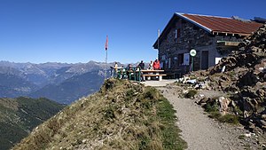
The Capanna del Tamaro ( German Tamarohütte ) is a refuge in the municipality of Monteceneri in the Valle del Trodo in the canton of Ticino in the Lugano Prealps at an altitude of 1867 m above sea level. M.
History and description
The hut was built in 1941 from a military shelter from the First World War and was renovated in 1953 and enlarged in 1988. It is located on the ridge that connects the Trodo Valley with the Duragno Valley and stands on the border between Sopra and Sottoceneri, about one kilometer from Monte Tamaro. It belongs to the Bellinzona section of the Unione Ticinese Operai Escursionisti (UTOE) under the umbrella organization Federazione Alpinistica Ticinese (FAT).
The two-story hut has two lounge / dining rooms with a total of 70 seats. The kitchen has a wood and gas stove as well as a bedroom for 12 to 16 people and an outdoor area with tables. Wood is used for heating and the lighting is electric.
Due to its location below the summit of Monte Tamaro , it is considered to be one of the most beautiful viewpoints in Ticino with a comprehensive view of the valley floor, to Bellinzona , Lugano with Lake Lugano and Lake Maggiore with Locarno .
Hut access with walking time
- From Alpe Foppa ( 1530 m above sea level ) in 1 hour (level of difficulty T1). Alpe Foppa can be reached by cable car from Rivera .
- From the Alpe di Neggia ( 1395 m above sea level ) in 1 ½ hours (T2). The Alpe di Neggia can be reached by public transport.
- From Rivera ( 470 m above sea level ) in 4 ½ hours (T2).
Hike
- Mountain trail from Monte Tamaro to Monte Lema ( 1619 m above sea level ) in 5 hours (T2).
Ascent
- Monte Tamaro ( 1961 m above sea level ) in 30 minutes.
Transitions to neighboring huts
- Capanna Alpetto di Caviano in 5 hours
literature
- Massimo Gabuzzi: Huts and rifugi in Ticino and Misox . Edizioni Salvioni, Bellinzona 2005, ISBN 978-88-7967-123-1

