CarCanMadCarLan
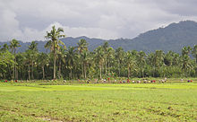
CarCanMadCarLan is a settlement area on the northern part of the east coast of Mindanao in the Province of Surigao del Sur , Philippines . The name is an artificial word that is a string of the first three letters of the five affected municipalities ( Carrascal , Cantilan , Madrid , Carmen and Lanuza ) (order from north to south).
Communities
| Surname | households | Residents | Area (km²) | Ew / km² |
|---|---|---|---|---|
| Carrascal | 2756 | 22,479 | 265.8 | 62.19 |
| Cantilane | 5378 | 31,492 | 240.10 | 125.91 |
| Madrid | 2862 | 15,223 | 141.00 | 105.59 |
| Carmen | 1873 | 10,347 | 160.01 | 64.29 |
| Lanuza | 1942 | 12.001 | 395.76 | 29.96 |
| together | 14,811 | 83,792 | 1202.67 | 69.67 |
location
The area is bounded geographically to the northeast by the Philippine Sea (Carrascal Bay and Lanuza Bay) and to the southeast, southwest and northwest by mountains. Politically and administratively it is roughly the northernmost quarter of the province of Surigao del Sur. Some of the rivers originating there are z. T. navigable, z. B. the Carac-an, the Union, the Cantilan, the Consuelo, the Benoni, the Bun-ot, the Adlayan and the Lancogue. Because of the volcanic activity of the area - it is part of the Pacific Ring of Fire - the risk of earthquakes and tsunamis in the coastal area is considered to be high, while in the mountainous parts the risk of landslides is greater. However, the offshore coral reefs offer protection from tsunamis. The maps, which represent the respective risk classifications of the territories by the authorities, are displayed in the town hall of Cantilan.
economy
There is agriculture (mainly rice and coconut palms), cattle breeding (pigs, chickens and water buffalo ) and coastal fishing. The whole of Lanuza Bay and the coastal waters to the northwest to Carrascal and southeast to Tandag are divided into several fishing zones, which are managed from Cantilan . In the north of Carrascal (Barangay Adlay) open-cast mining is carried out on a large scale in order to extract the iron ore and nickel that are abundant there in the “Red Mountains”. In dry weather, the dust pollution in the air is correspondingly high. The usual Philippine retail trade in the form of so-called sari-sari stores is widespread. The area is hardly developed for tourism, but surf competitions take place in Lanuza every year in November, as Lanuza Bay offers favorable wind conditions for surfers, especially in the months between November and March.
history
The area used to be known for its vast forests and swamps. As a result of state irrigation projects, over 6000 hectares are now used as rice fields. The relevant measures began in the 18th century by monks "stationed" there. The use of the rivers for breeding fisheries did not begin until the beginning of the 20th century.
From the second half of the 16th century to 1919, the entire area of around 1200 km² was named Cantilan . On December 10, 1918, the area was divided into three parts ( Carrascal , Cantilan, Lanuza ) by Order No. 52 of the American Governor General Francis Burton Harrison . The order became final when his successor, Charles Yeater , signed it, giving the acronym “CarCanLan”. On February 2, 1953, that changed to "CarCanMadLan" because Madrid was given the status of an independent municipality on the basis of an order from President Elpidio Quirino . Since finally Carmen , formerly a district of Lanuza, on August 16, 1971 by “Republic Act No. 6367 ”received this status, the entire area of the former“ Groß-Cantilan ”is now called CarCanMadCarLan.
traffic
The region is traversed by the mainly concreted Surigao - Tandag coastal road . There are also ports in Cantilan and Lanuza . In Cantilan, however, one port (in the Cantilan River ) is only accessible for special watercraft (" pump boats ") with a very shallow draft (≈0.3 m), while the other (Consuelo Port Map ) can also be used by ships with a greater draft. The nearest airport in Tandag has been in operation again since 2014.
Culture
The itik-itik dance ( duck dance) has its origin there.
climate
| CarCanMadCarLan, Philippines | ||||||||||||||||||||||||||||||||||||||||||||||||
|---|---|---|---|---|---|---|---|---|---|---|---|---|---|---|---|---|---|---|---|---|---|---|---|---|---|---|---|---|---|---|---|---|---|---|---|---|---|---|---|---|---|---|---|---|---|---|---|---|
| Climate diagram | ||||||||||||||||||||||||||||||||||||||||||||||||
| ||||||||||||||||||||||||||||||||||||||||||||||||
Like all of Mindanao, the area has a tropical climate. Average monthly rainfall is 257.2 mm (10.13 in). The rainy season is from November to March, the dry season from April to September. But even in the latter there are often evening showers and thunderstorms, which the locals call Sobasco . The entire area is hit by typhoons, the penultimate larger (named "Pablo") claimed at the beginning of December 2012 according to the "Manila Bulletin" in the province of Davao de Oro further south, at least 236 dead. The last one (called "Haiyan") passed Mindanao north and on November 8, 2013 caused great destruction on the islands of Samar and Leyte . There is talk of around 10,000 dead.
literature
- Eulogio Eleazar: History of Cantilan. 1980.
Web links
- Carcanmadcarlan's Brief History . tilang.tripod.com.
- Surigao Travel Guide - Cantilan.net
- PSGC: Towns and municipalities of the province "Surigao del Sur"
Remarks
credentials
- ↑ http://www.typhoon2000.ph/activetrack.gif
- ↑ http://www.tagesschau.de/ausland/philippinen442.html ( Memento from November 10, 2013 in the Internet Archive )
- ↑ http://www.tagesschau.de/ausland/philippinen466.html ( Memento from November 10, 2013 in the Internet Archive )
Coordinates: 9 ° 17 ′ 0 ″ N , 125 ° 57 ′ 0 ″ E


