Surigao City
| Surigao City | ||
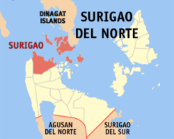
| Location of Surigao City in the province of Surigao del Norte | ||
|---|---|---|

|
||
| Basic data | ||
| Region : | Caraga | |
| Province : | Surigao del Norte | |
| Barangays : | 54 | |
| District: | 2. District of Surigao del Norte | |
| PSGC : | 166724000 | |
| Income class : | 2nd income bracket | |
| Households : | 22,541 May 1, 2000 census
|
|
| Population : | 154.137 August 1, 2015 census
|
|
| Population density : | 628.3 inhabitants per km² | |
| Area : | 245.34 km² | |
| Coordinates : | 9 ° 47 ′ N , 125 ° 29 ′ E | |
| Postal code : | 8400 | |
| Area code : | +63 86 | |
| Website: | www.surigaocity.gov.ph | |
| Geographical location in the Philippines | ||
|
|
||
Surigao City is a Filipino city in the Surigao del Norte Province . Surigao City is the capital of the province.
geography
Surigao City is made up of a mosaic of islands on the edge of the continental shelf of Asia. Surigao City is located on the northeast tip of Mindanao Island , in the southern Philippines. To the north and east is the Pacific Ocean . In the south it borders the province of Agusan del Norte and the province of Surigao del Sur in the west.
The main part of the city on Mindanao has an irregular or hilly topography, the islands near the coast are flat.
The average height is 19 meters above sea level . The highest point in the mainland at 465 m above sea level is in the Kabangkaan Ridge , along the border with the municipality of San Francisco .
Along the border with Tagana-an lies the summit of Mapawa at 245 m above sea level on the sloping slopes of which are the barangays Cabongbongan, Nabago and Capalayan.
The highest point on the members of the city islands is 263 m above sea level on the island Nontoc that the Cantiasaykanal and the island Hanigad dominated m with a peak altitude of 163 above sea level. The highest point on the island of Hikdop is the summit of Telegrapo at 250 m above sea level. Bayagnan Island in the eastern part of the city has a maximum height of 242 m above sea level.
Barangays
Surigao City is politically divided into 54 barangays . Of the 54 barangays, 33 are on the mainland and 21 on the offshore islands. The main town consists of five barangays: Taft, Washington, San Juan, Canlanipa and Luna. 36 barangays are on the coast, of which 15 are on the mainland and 21 on the offshore islands.
|
|
|
history
Today's city center was previously called Banahao and was a port for the so-called Bilan-Bilan ships .
Banahao belonged to the old Caraga district , which later became the politico-military district Surigao with the seat of government in the town of Tandag (today the capital of the Surigao del Sur province ).
Surigao officially became the permanent residence of the Récollets , a French branch of the Franciscan Order , on February 1, 1752 , after all the canonical books were brought here from the island of Siargao . The first canonical book is signed by the monk Lucas de la Cruz. Before that, Surigao was just a vista of the parish in Caolo on Siargao.
The fleet of Ferdinand Magellan sailed on their trip around the world and after a short stay on the island homonhon by the Surigao Strait .
During the Second World War, on October 24-25, 1944, the battle between the United States and the Japanese fleet took place here on the Strait of Surigao .
Surigao City is named after the old district (province) of the same name. It is not clear what the name is derived from. The name is probably derived from the Spanish word surgir , which means "bubbling water" or "current".
With the division of Surigao into two provinces, Surigao del Sur and Surigao del Norte, the municipality of Surigao became the capital of Surigao del Norte. Surigao became a "notarized city" on August 31, 1970.
