Gigaquit
| Municipality of Gigaquit | ||
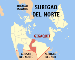
| Location of Gigaquit in the province of Surigao del Norte | ||
|---|---|---|

|
||
| Basic data | ||
| Region : | Caraga | |
| Province : | Surigao del Norte | |
| Barangays : | 13 | |
| District: | 2. District of Surigao del Norte | |
| PSGC : | 166711000 | |
| Income class : | 4. Income bracket | |
| Households : |
May 1, 2000 census
|
|
| Population : | 20,864 August 1, 2015 census
|
|
| Population density : | 151.1 inhabitants per km² | |
| Area : | 138.11 km² | |
| Coordinates : | 9 ° 36 ′ N , 125 ° 42 ′ E | |
| Postal code : | 8409 | |
| Geographical location in the Philippines | ||
|
|
||
Gigaquit ( Filipino : Bayan ng Gigaquit ) is a Filipino municipality in the province of Surigao del Norte , Administrative Region XIII, Caraga. It has 20,864 inhabitants (August 1, 2015 census) who lived in 13 barangays . It is classified as a fourth income class community in the Philippines and as partially urbanized .
Gigaquit is located on the coast of the Philippine Sea , approx. 61 km southeast of Surigao City and can be reached via the Surigao City - Tandag coastal road. Their neighboring communities are Bacuag in the northwest, Claver in the east and Alegria in the west.
Barangays
- Alambique (Pob.)
- Anibongan
- Cam-boayon
- Camam-onan
- Ipil (Pob.)
- Lahi
- Mahanub
- Poniente
- San Antonio (Bonot)
- San Isidro (Parang)
- Sico-sico
- Villaflor
- Villafranca
