Claver (Surigao del Norte)
| Claver Parish | ||
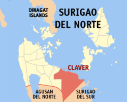
| Location of Claver in the province of Surigao del Norte | ||
|---|---|---|

|
||
| Basic data | ||
| Region : | Caraga | |
| Province : | Surigao del Norte | |
| Barangays : | 14th | |
| District: | 2. District of Surigao del Norte | |
| PSGC : | 166706000 | |
| Income class : | 4. Income bracket | |
| Households : | 3248 May 1, 2000 census
|
|
| Population : | 32,773 August 1, 2015 census
|
|
| Coordinates : | 9 ° 34 ′ N , 125 ° 44 ′ E | |
| Postal code : | 8410 | |
| Geographical location in the Philippines | ||
|
|
||
Claver is a municipality in the Philippines in the province of Surigao del Norte .
It is located in the north of the large island of Mindanao , 60 km southeast of the provincial capital Surigao City and can be reached via the Surigao City - Tandag coastal road.
It has 32,773 inhabitants (August 1, 2015 census). Large parts of the community area are mining areas for the exploitation of the largest iron ore deposits in the world. The mineral is extracted in the "Red Mountains" by means of open-cast mining, transported directly to the coast on specially constructed slopes and then shipped there. The Taganito Mining Corporation and its Japanese owner Sumitomo Kinzoku Kōzan are significantly involved in mining.
Barangays
Claver is politically divided into 14 barangays .
- Bagakay (Pob. West)
- Cabugo
- Cagdianao
- Daywan
- Hayanggabon
- Ladgaron (Pob.)
- Lapinigan
- Magallanes
- Panatao
- Sapa
- Taganito
- Tayaga (Pob. East)
- Urbiztondo
- Wangke
