Homonhon
| Homonhon | ||
|---|---|---|
| Waters | Pacific Ocean | |
| Geographical location | 10 ° 44 ' N , 125 ° 43' E | |
|
|
||
| length | 20 km | |
| Location of Homonhon | ||
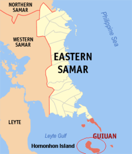
Homonhon is an island belonging to the Philippines . It is politically assigned to the province of Eastern Samar and belongs to the independently administered municipality of Guiuan . The island marks the eastern edge of the Gulf of Leyte . It is located east of the island of Leyte and lies below the southern foothills of the island of Samar . It has an extension of 20 km.
history
After crossing the Pacific , the three ships that were left of Ferdinand Magellan's fleet passed the islands of the Mariana Islands and on March 16, 1521 reached the island of Humunu (former name of the island of Homonhon). Here you went ashore to stock up on more supplies. Shortly afterwards, the fleet of boats belonging to the local Rajah Calambus, who ruled the neighboring island of Limasawa , was discovered. The language of the locals was known to Magellan's Malay slave and interpreter Enrique Melaka , who thus became the first person to return to his home region after traveling around the world. Through the interpreter Enrique Magellan managed to get in touch with the ruler of Limasawa and to exchange gifts with him.
The day they landed was a Sunday during the festival in honor of St. Lazarus and today marks the arrival of the Christian faith in the Philippines.
Magellan himself gave the island the name "Homonhon" , which means "island of the waterhole full of good signs" .
See also
Footnotes
- ^ WD Brownlee (Master Mariner), 1974. The First Ships Around the World ISBN 0-8225-1204-1 , p. 44.
- ^ Richard Humble, The Voyage of Magellan , Franklin Watts [1988] ISBN 0-531-10638-1 p. 20.
- ↑ Laurence Bergreen, Over the Edge of the World: Magellan's Terrifying Circumnavigation of the Globe HarperCollins Publishers [2003] ISBN 0-06-621173-5

