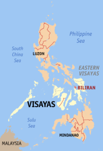
Biliran
| Basic data | |
|---|---|
| Region : | Eastern Visayas |
| Capital : | Naval |
| Population : | 171,612 August 1, 2015 census
|
| Population density : | 320 inhabitants per km² |
| Area : | 536.01 km² |
| PSGC : | 087800000 |
| structure | |
| - Highly urbanized cities | |
| - provincial cities | |
| - municipalities | 8th |
| - Barangays | 132 |
| - electoral districts | 1 |
| Location of the province in the Philippines | |

|
|
Coordinates: 11 ° 31 ' N , 124 ° 32' O Biliran is an island in the Samar Sea and since 1992 an autonomous province of the Philippines . The provincial capital is Naval .
Before its political independence, the island belonged to the province of Leyte . The island is located in the eastern Visayas, north of Leyte and west of Samar . The total area of the island is 536.01 square kilometers. 55% of it is agricultural land and 23% is forested area.
Biliran has 171,612 inhabitants (August 1, 2015 census). The population lives mainly from fishing and agriculture. Mainly rice, corn, vegetables and coconut palms are grown.
There are eight cities in the province, which are divided into 132 barangays .
Biliran has hardly been developed for tourism so far. The remaining tropical rainforest, some waterfalls, hot springs and currently dormant volcanoes are attractions. The province also includes Maripipi Island , which was formed by volcanic forces and marks the northernmost extension of the province. Higatangan Island marks the westernmost extension of the province. Other smaller islands are Dalutan , Caygan , Sambawan and Capinahan Island .
geology
Geologically speaking, the island is a complex volcano . The highest of the many lava domes is the Surio at 1301 m above sea level. The rock of the island consists mainly of andesite .
Investigations using the radiocarbon method have shown the formation of the island in the Pleistocene , through the formation of a volcanic center in the north of today's island of Biliran. Fumarolic fields and hot springs cover the 20 × 35 km island. The only known volcanic activity was a phreatic explosive eruption in 1939.
Municipalities with the associated barangays
- Almeria (Caucab, Iyosan, Jamorawon, Lo-ok, Matanga, Pili, Poblacion, Pulang Bato, Salangi, Sampao, Tabunan, Talahid, Tamarindo).
- Biliran (Bato, Burabod, Busali, Hugpa, Julita, Canila, Pinangumhan, San Isidro, San Roque, Sanggalang, Villa Enage).
- Cabucgayan (Balaquid, Baso, Bunga, Caanibongan, Casiawan, Esperanza, Langgao, Libertad, Looc, Magbangon, Pawikan, Salawad, Talibong).
- Caibiran (Alegria, Asug, Bari-is, Binohangan, Cabibihan, Kawayanon, Looc, Manlabang, Caulangohan, Maurang, Palanay, Palengke, Tomalistis, Union, Uson, Victory, Villa Vicenta).
- Culaba (Acaban, Bacolod, Binongtoan, Bool Central, Bool East, Bool West, Calipayan, Guindapunan, Habuhab, Looc, Marvel, Patag, Pinamihagan, Culaba Central, Salvacion, San Roque, Virginia).
- Kawayan (Baganito, Balacson, Bilwang, Bulalacao, Burabod, Inasuyan, Kansanok, Mada-o, Mapuyo, Masagaosao, Masagongsong, Poblacion, Tabunan North, Tubig Guinoo, Tucdao, Ungale, Balite, Buyo, Villa Cornejo, San Lorenzo).
- Maripipi (Agutay, Banlas, Bato, Binalayan West, Binalayan East, Burabod, Calbani, Canduhao, Casibang, Danao, Ol-og, Binongto-an, Ermita, Trabugan, Viga)
- Naval (Agpangi, Anislagan, Atipolo, Calumpang, Capiñahan, Caraycaray, Catmon, Haguikhikan, Padre Inocentes Garcia, Libertad, Lico, Lucsoon, Mabini, San Pablo, Santo Niño, Santissimo Rosario, Talustusan, Villa Caneja, Villa Consuelungo, Borac , Imelda, Larrazabal, Libtong, Padre Sergio Eamiguel, Sabang).
Web links
- Biliran in the Global Volcanism Program of the Smithsonian Institution (English)
- NSCB statistics on Biliran Province
- The province on the Philippines Department of Agriculture website
- More information about the province on biliranisland.com
