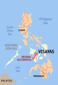
Negros Occidental
| Basic data | |
|---|---|
| Region : | Western Visayas |
| Capital : | Bacolod City |
| Population : | 2,497,261 August 1, 2015 census
|
| Population density : | 320 inhabitants per km² |
| Area : | 7,802.50 km² |
| PSGC : | 064500000 |
| Official website: | negros-occ.gov.ph |
| structure | |
| - Highly urbanized cities | 1 |
| - provincial cities | 13 |
| - municipalities | 19th |
| - Barangays | |
| - electoral districts | 5 |
| Location of the province in the Philippines | |

|
|
Coordinates: 10 ° 12 ' N , 123 ° 0' E
Negros Occidental (German: West Negros ) is a province of the Philippines in the Western Visayas region . The provincial capital is the independent city of Bacolod City . The population is 2,497,261 (August 1, 2015 census) and the area is 7,802.5 km². It comprises a total of 13 partially urban cities and 17 larger urban communities. 80% percent of all land is cultivated.
geography
The province of Negros Occidental comprises the north and west of the island of Negros . The province is approx. 375 km long, running from southwest to northeast. It is bounded by the Visayas Sea in the north, the Gulf of Panay and the Guimaras Straits in the west, the Tanon Strait and the province of Negros Oriental in the east and the Sulu Sea in the southwest. There are some smaller islands off the coast , such as Sipaway Island off the east coast or Danjugan Island off the west coast.
The north and west of the province form large, flat, undulating plains, most of which are used for agriculture. The volcanic mountain range of the Marappa Mountains is located in the northern center of the province, in it lie the volcanoes Silay and Mandalagan . South of the mountain range rises the 2,465 meter high Kanlaon volcano and is the highest mountain in the Visayas . In the east and south-west, the topography of the province is determined by a series of flat mountain ranges and hilly plateaus , which extend to the coastline in the south-west. In the southwest of the province lies the catchment area of the Ilog River , which forms a 50 km² delta at its mouth.
climate
The province lies in the tropical climate zone and falls under climate type one with a pronounced dry and rainy season. The dry season starts in December and ends in May and the rainy season starts in June and ends in November. The mean annual temperature is approx. 26 ° C, the warmest months are April and May. The coldest months are December, January and February.
history
The province of Negros Occidental was established in 1734 when Negros became an independent military district of the Spanish colonial administration with its headquarters in Ilog (?). In 1795, the provincial headquarters were relocated to Himamaylan, only to be relocated to Bacolod in 1849. When the province of Negros Oriental was split off on January 1, 1890, the province was given its present-day borders.
Spanish colonial rule was ended during the Philippine Revolution on November 5, 1898 by the Negro Revolutionary Forces, led by General Aniceto Lacson and Juan Araneta, and the Katipunan National Movement allied with them . The then newly founded Cantonal Government of the Republic of Negros was overthrown in May 1898 by the invasion of the USA and a provisional military administration was set up. Only on April 20, 1901, a civil provincial administration was reinstated by the colonial administration.
During the Japanese occupation in World War II , the military resistance of Gov. Alfredo Montelibano organized. After Negros was liberated in the Battle of the Visayas in 1945, the damage on the island, some of which was great, was gradually removed.
The socio-economic development of the province depends crucially on the cultivation and processing of sugar cane . Since the middle of the 19th century, ever larger areas of the province were made arable for the cultivation of sugar cane. In the 1950s and 1960s the province produced about 60% of the total sugar production in the Philippines, which earned the province the nickname of the sugar province and made the province highly dependent on the cultivation of sugar cane and its end products. This development led to a socio-economic crisis in the province in the 1980s. In 1983 a prolonged drought led to significant crop failures and in 1984 large parts of the crop were destroyed by the Typhoons Nitang and Undang. In addition, world market prices for sugar collapsed, which in turn led to a decline in the national product and social impoverishment of the population. This process culminated in 1986 in a referendum to secede the province of Negros Nord, which, however, was declared null and void by the Constitutional Court of the Philippines in the same year. Since 1987, agriculture in the province has paid greater attention to diversification in the cultivation of agricultural crops. In addition, the tourism sector is to be developed and other industries settled in order to further reduce dependence on sugar cane.
Negros Occidental was part of the Negros Island Region, which existed from 2015 to 2017 .
Cities
|
Communities
National parks and nature reserves
- Mount Kanlaon Natural Park
- Northern Negros Natural Park
- Sagay Marine Reserve
- Ilog-Hilabangan Watershed Forest Reserve
- Kabankalan Watershed Forest Reserve
Educational institutions
Web links
- Negros Occidental Provincial Government website
- Negros Occidental Tourism Situationer 2008–2009 (PDF; 4.67 MB) Negros Occidental Tourism Center
- Negros Inside
- Negros Occidental at wowPhilippines


