Enrique B. Magalona
| Municipality of Enrique B. Magalona | ||
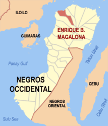
| Location of Enrique B. Magalona in the province of Negros Occidental | ||
|---|---|---|

|
||
| Basic data | ||
| Region : | Western Visayas | |
| Province : | Negros Occidental | |
| Barangays : | 23 | |
| District: | 3. District of Negros Occidental | |
| PSGC : | 064508000 | |
| Income class : | 2nd income bracket | |
| Households : |
May 1, 2000 census
|
|
| Population : | 62,921 August 1, 2015 census
|
|
| Population density : | 557.3 inhabitants per km² | |
| Area : | 112.90 km² | |
| Coordinates : | 10 ° 53 ' N , 122 ° 58' E | |
| Postal code : | 6120 | |
| Geographical location in the Philippines | ||
|
|
||
Enrique B. Magalona is a municipality in the Province of Negros Occidental on the island of Negros in the Philippines . It has 62,921 inhabitants (August 1, 2015 census) who live in 23 barangays . It belongs to the second income bracket of the communities in the Philippines and is described as partially urbanized .
The city was originally called Saravia and was named after the first Spanish military governor of Negros, Don Emilio Saravia, who was in office from 1856 to 1858 . By a law of the House of Representatives ( House Bill 511 ), the community was renamed Enrique B. Magalona on the initiative of MP Armando Gustilo on August 19, 1967 after the former Senator Enrique Magalona , who died in 1960 .
It is located approximately 24 km north of Bacolod City . The journey time is approx. 45 minutes by bus and approx. 35 minutes by car. Its northern border is the Guimaras Strait , which separates Negros from Panay Island. Victoria's City borders the parish to the east and Silay City is to the west. The Silay volcano rises to the east of the municipality .
The rice terraces in Sitio Tabuan, Barangay San Isidro are considered to be the counterpart to the rice terraces of Banaue in the Filipino Cordillera . The monument commemorating the Battle of Guintabuan is located in Sitio Guintabuan. The 42-hectare mangrove reserve Century-old Mangrove is located at Sitio Buyog in the Bgry. Alicante. The Dabo Dabo waterfalls and the bat sanctuary are in the Brgy. Canlusong approx. 35 km from the town center.
Barangays
|
|
|
swell
- Information about Enrique B. Magalona at the Philippine Statistics Bureau
- Enrique B. Magalona on the website of the Province of Negros Occidental
Individual evidence
- ↑ Municipality of Enrique B. Magalona ( Memento of the original from October 6, 2015 in the Internet Archive ) Info: The archive link was inserted automatically and has not yet been checked. Please check the original and archive link according to the instructions and then remove this notice. on the homepage of the Province of Negros Occidental
