Kabankalan City
| Kabankalan City | ||
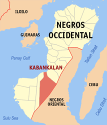
| Location of Kabankalan City in the Negros Occidental Province | ||
|---|---|---|

|
||
| Basic data | ||
| Region : | Western Visayas | |
| Province : | Negros Occidental | |
| Barangays : | 32 | |
| District: | 6. District of Negros Occidental | |
| PSGC : | 064515000 | |
| Income class : | 1st income bracket | |
| Households : |
May 1, 2000 census
|
|
| Population : | 181,977 August 1, 2015 census
|
|
| Population density : | 261.1 inhabitants per km² | |
| Area : | 697 km² | |
| Coordinates : | 9 ° 59 ′ N , 122 ° 49 ′ E | |
| Postal code : | 6111 | |
| Area code : | +63 34 | |
| Mayor : | Isidro Zayco | |
| Website: | www.kabankalancity.gov.ph | |
| Geographical location in the Philippines | ||
|
|
||
Kabankalan City is located on Negros Island in the Negros Occidental Province . It is a first-income city in the Philippines . The city is classified as partially urbanized and is the economic engine of the southern region of Negros Occidental. It can be reached in a good two hours from the provincial capital Bacolod City via the coastal highway. The city is connected to Dumaguete in Negros Oriental via the Kabankalan-Mabinay Highway . The Kabankalan City Domestic Airport is to be completed by June 2014. The construction costs for this infrastructure project amount to 642 million Philippine pesos .
geography
The area of the city of Kabankalan borders on the city of Himamaylan City and the Gulf of Panay to the north, the province of Negros Oriental to the east and the municipality of Ilog to the west . The city covers an area of 69,735 hectares and Kabankalan is divided into 32 barangays . The population of the city is put at 181,977 people. Kabankalan City is located in the Ilog River catchment area .
history
The first mention of Kabankalan goes back to the 1630 decade in the records of Admiral Cristobal de Logo y Montalvo. The Jesuit order began the Christianization of Negros at this time .
Until March 14, 1907, Kabankalan was part of the municipality of Ilog. With the implementation of the Philippine Commission Act 1612, Kabankalan was granted the status of a municipality. The status of a large city was granted to Kabankalan on August 2, 1997 under the President Fidel Ramos , based on the Republic Act 8297.
Attractions
The Mag-aso waterfalls are located in the mountainous part of the city and can be reached after a twenty-minute drive. The water produces a slight mist when it falls into the lake with turquoise green water. The Mag-aso cave is 436.54 meters long and has a height difference of approx. 149 meters, it is one of the largest caves in the Philippines.
The Freedom Fighter Shrine commemorates the Filippinos' liberation struggle in World War II . The Ilog-Hilabangan Watershed Forest Reserve is inland from the city.
Barangays
|
|
|
