Pontevedra (Negros Occidental)
| Municipality of Pontevedra | ||
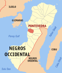
| Location of Pontevedra in the province of Negros Occidental | ||
|---|---|---|

|
||
| Basic data | ||
| Region : | Western Visayas | |
| Province : | Negros Occidental | |
| Barangays : | 20th | |
| District: | 4. District of Negros Occidental | |
| PSGC : | 064521000 | |
| Income class : | 3rd income bracket | |
| Households : |
May 1, 2000 census
|
|
| Population : | 51,866 August 1, 2015 census
|
|
| Population density : | 461 inhabitants per km² | |
| Area : | 112.50 km² | |
| Coordinates : | 10 ° 22 ' N , 122 ° 52' E | |
| Postal code : | 6105 | |
| Geographical location in the Philippines | ||
|
|
||
Pontevedra is a municipality in the west of the Negros Occidental province on the island of Negros in the Philippines . It has 51,866 inhabitants (August 1, 2015 census) who live in 20 barangays . It belongs to the third income bracket of the communities in the Philippines and is described as partially urbanized .
It is about 49 km south of Bacolod City . The journey time is around 60 minutes by bus or jeepney , and around 45 minutes by car. Its neighboring communities are San Enrique , La Carlota City in the north, La Castellana in the east, Hinigaran in the south and in the west the community borders on the Gulf of Panay .
In the municipality is the Saint Michael the Archangel Church , which has a capacity of 1,500 people and whose windows are decorated with motifs of the actions of the Archangel Michael .
Barangays
|
|
