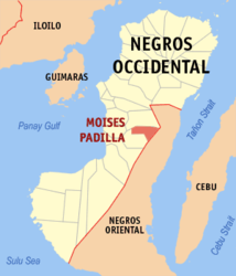
Moises Padilla
| Municipality of Moises Padilla | ||
| Location of Moises Padilla in the province of Negros Occidental | ||
|---|---|---|

|
||
| Basic data | ||
| Region : | Western Visayas | |
| Province : | Negros Occidental | |
| Barangays : | 15th | |
| District: | 5. District of Negros Occidental | |
| PSGC : | 064519000 | |
| Income class : | 4. Income bracket | |
| Households : |
May 1, 2000 census
|
|
| Population : | 41,386 August 1, 2015 census
|
|
| Population density : | 288 inhabitants per km² | |
| Area : | 143.70 km² | |
| Coordinates : | 10 ° 15 ′ N , 123 ° 5 ′ E | |
| Postal code : | 6132 | |
| Geographical location in the Philippines | ||
|
|
||
Moises Padilla is a municipality in the province of Negros Occidental on the island of Negros in the Philippines . It has 41,386 inhabitants (August 1, 2015 census) who live in 15 barangays . It belongs to the fourth income bracket of the communities in the Philippines and is described as partially urbanized .
It is located about 85 km southeast of Bacolod City . Travel time is around two hours by bus or jeepney . Its neighboring communities are La Castellana in the north, Guihulngan City in the province of Negros Oriental in the east, the community of Isabela forms the southern border. The topography of the municipality is described as mountainous, it is located in the mountains of the island of Negros south of the Kanlaon volcano .
The Old Municipal Building is a historic building for the community. The Kaitulari Eco-tourism Zone is located on the territory of the municipality and offers tourists the opportunity to get acquainted with the nature of the island.
Barangays
|
|
|
