Silay City
| Silay City | ||
| Location of Silay City in the Negros Occidental Province | ||
|---|---|---|

|
||
| Basic data | ||
| Region : | Western Visayas | |
| Province : | Negros Occidental | |
| Barangays : | 16 | |
| District: | 6. District of Negros Occidental | |
| PSGC : | 064526000 | |
| Income class : | 2nd income bracket | |
| Households : | 6699 May 1, 2000 census
|
|
| Population : | 126,930 August 1, 2015 census
|
|
| Population density : | 126930 / 214.80 inhabitants per km² | |
| Area : | 214.80 km² | |
| Coordinates : | 10 ° 48 ' N , 122 ° 58' E | |
| Postal code : | 6116 | |
| Mayor : | Jose L. Montelibano | |
| Website: | www.silaycity.gov.ph | |
| Geographical location in the Philippines | ||
|
|
||
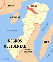
Silay City is located in the province of Negros Occidental in the northeast of the island of Negros . It is a second income city in the Philippines . The city's coat of arms is composed as follows: The sixteen stars symbolize the sixteen barangays of the city. In the center of the coat of arms is a sugar mill and symbolizes the most important local industry , the sugar plant and the fish symbolize the most important livelihoods of the people of Silay City. The Kansilay tree and the Santan flower are the official plants of Silay City and refer to the founding myth of Princess Kansilay. The city even has an official city song: the "Martsa Sang Silaynon" song.
geography
The city is bordered to the west by Guimaras Straits , which separate the Negros and Panay Island . In the north, Silay City borders on the territory of the municipality of Enrique B. Magalona , in the east the Marapara Mountains with the mighty appearance of the Silay volcano border the urban area. In the south, Silay City borders on the Talisay City area , which separates it from the provincial capital of Negros Occidental Bacolod City, 14 km away .
Land use
The land use of the city and its administrative area is indicated as follows: Residential development: 624.5 hectares Trade: 59.80 hectares Industry: 91.70 hectares Agriculture: 2,838.704 hectares Forests: 17,865.00 hectares
The area of the city is given as 214.80 km².
Attractions
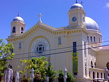
The San Diego Pro-Cathedral is the only Prokathedrale outside Metro Manila in the Philippines. It was built in 1920 and designed by the Italian architect Antonio Bernasconi.
The Hawaiian Philippines Co.'s steam locomotives , also known as the Iron Dinosaurs, are the oldest surviving locomotives in the Philippines. In the past they were mainly used to transport sugar cane .
A museum is housed in the Bernardino-Jalandoni house . The architecture of the house is considered a prime example of early 20th century architecture in the Philippines.
The Hofileña Ancestral House exhibits works of art by contemporary artists from the Philippines. The works of art belong to the collection of Ramon H. Hofileña.
The city park of Silay City was opened in 1951 and is considered one of the most beautiful parks in the Philippines.
The Friendship Shrine is a memorial in memory of the victims of the Second World War .
The Cinco de Noviembre marker is a memorial to commemorate the November 5, 1898 revolution against Spanish colonial rule, which took place in Silay City without bloodshed.
The Patag Valley is about 38 km from the city center, in it you can visit the remains of the remains of the Imperial Japanese Army, including several tunnels. In the Patag Tourist Zone , visitors can take advantage of the sulfur springs and enjoy the impressive landscape, which also includes several waterfalls , large rocky cliffs and the impressive flora and fauna .
The mangrove forest on the coast is a protected nature park.
Barangays
|
|

