Panaon (island)
| Panaon | ||
|---|---|---|
| Wawa Bridge, Panaon on the right, Leyte on the left | ||
| Waters | Lake Mindanao , Sogod Bay , Strait of Surigao | |
| Archipelago | Visayas ( Philippines ) | |
| Geographical location | 10 ° 3 ' N , 125 ° 13' E | |
|
|
||
| length | 32 km | |
| Highest elevation | 621 m | |
| main place | Liloan , Pintuyan , San Francisco , San Ricardo | |
| Map of Southern Leyte with the island of Panaon at the bottom right | ||
Panaon is an island in the Philippines , in the Southern Leyte Province .
geography
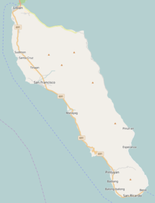
The island lies south of Leyte , and is separated by the Strait of Surigao from Dinagat in the east and Mindanao in the southeast. Lake Mindanao lies to the southwest. Panaon is 32 km long from north to south. The largest city is Liloan , which is connected to the main island Leyte by the so-called Wawa Bridge . Panaon is made up of the boroughs of Liloan, San Francisco , Pintuyan, and San Ricardo .
Demographics and language
The island is populated by different ethnic groups, the Visayan and the Cebuano as well as the Waray. Cebuano and Wáray-Wáray are mainly spoken. In addition, are English and Tagalog as widespread communication possibilities. The majority of the population is Christian and belongs to the Roman Catholic faith.
economy
The most common form of livelihood is harvesting coconuts, rice, and edible green leaves, and fishing.
tourism
Scuba diving (especially for whale sharks ) and whale watching (locally called Tikitiki ) are popular tourist attractions. A special attraction is the belonging to the town of San Francisco Napantao, both the underwater world for snorkeling and to scuba diving invites.
See also
Web links
Individual evidence


