Carrowmore

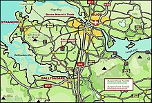
Carrowmore ( Irish An Cheathrú Mhór "the great quarter") in County Sligo is the most concentrated (mostly arranged in rows) accumulation between 4000 and 2500 BC. Chr. In the Neolithic built megaliths in Ireland . Most of the better-preserved 25 systems, from once over 80 (some say over 200), are located on an area of more than three square kilometers near the access road.
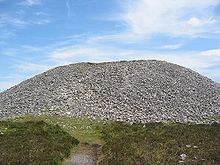
They mainly consist of small passage tombs and dolmens . Few of them still have the circle of curbs, as they were probably originally under a cairn . The complexes are older than Newgrange and belong to the beginning of the Irish megalithic (circa 3850 BC). The largest complex in the area (No. 51) is Listoghil , a passage tomb with rock carvings, excavated under a cairn . Plant No. 7 - according to the numbering by G. Petries from 1837 - has a certain resemblance to the Danish Runddysse Poskær Stenhus on Djursland . In some ways, the Carrowmore complexes are atypical passage graves. For example, none of the passage tombs (Eng. Passage graves) has a tunnel-like passage which is a feature of most Irish passage graves, and only Tomb 51, (Listoghil) has a cairn .
Dating problems
In Western Europe, some megalithic systems seem to have been built very early. There are radiocarbon dates from the late 6th and early 5th millennium BC for the cairn of Barnenez and Île Guennoc in Brittany , for Bougon near Poitiers and for Chã da Parada in northwest Portugal. In Brittany, stone structures with corpses were burned to about 5200 BC on the Île d'Hœdic and near Téviec in the Morbihan. Dated and classified as Mesolithic. Mesolithic microliths (flint tools) were found in a passage tomb in Dissignac in the Loire-Atlantique department . The systems on the Isles of Scilly apparently also provided early data . However, all of this data cannot be classified chronologically and must be incorrect.
Plant No. 27 by Carrowmore is a passage tomb with a cruciform chamber. It is one of the greatest monuments in Carrowmore. Here the arrangement of Dowth (near Newgrange) with four central pillars is anticipated. However, the construction date (3825 BC), as well as that of plant No. 1, 4, 7 and 51 are unlikely to be correct. New C-14 dates revise the older dates, at least for Listoghil.
Others
Ring forts and some menhirs can also be found in the area .
The Cuir-irra, (Irish: Choch bhreac - or Cloch Liath) the gray or speckled stone is a perforated stone that marked the border point of three parishes. It has a rectangular hole measuring 90 cm x 60 cm. Nearby is the Knocknarea , a 350 m high natural hill on which, among other things, lies a huge cairn , known as Queen Maeve's Grave . The Carrowmore site has a visitor center that has been open in summer since 1990.
This area should not be confused with the archaeologically interesting Loch na Ceathrún Móire (English Carrowmore Lake ) in County Mayo .
See also
- Carrowmore after Wood-Martin 1886/87
literature
- Seán Ó Nualláin: Survey of the megalithic tombs of Ireland. Volume V: County Sligo 1989 ISBN 0-7076-0080-4
- Jürgen E. Walkowitz: The megalithic syndrome. European cult sites of the Stone Age (= contributions to the prehistory and early history of Central Europe. Vol. 36). Beier & Beran, Langenweißbach 2003, ISBN 3-930036-70-3 .
Web links
- Pictures from Listoghil (last accessed on December 10, 2012) ( Memento from September 27, 2007 in the Internet Archive ) Pictures from Listoghil (last accessed on December 10, 2012)
- English-language description of the facilities in Carrowmore (last accessed on December 10, 2012) English-language description of the facilities in Carrowmore (last accessed on 10 December 2012)
- The Cuir-irra, (Choch bhreac - or Cloch Liath) with picture
Coordinates: 54 ° 15 ′ 3.1 ″ N , 8 ° 31 ′ 9 ″ W.


