Cerová vrchovina
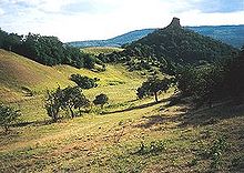
The Cerová vrchovina (literally: " Zerreich -Bergland") is a mountainous region in the south-center of Slovakia , in the Banskobystrický kraj . It belongs to the Mátra-Slanec area (in Hungary: Northern Hungarian Central Mountains), which in turn belongs to the Western Carpathians . The Cerová vrchovina is elongated from west to east and is bordered from the north by the Juhoslovenská kotlina (southern Slovak basin) and from the south by the border between Slovakia and Hungary .
It is an extinct volcanic mountain range, the formation of which is dated to the Pliocene and Pleistocene ages . The highest point is the Karanč (Karancs) on the Hungarian border ( 725 m nm ). The mountains are drained by the Ipeľ rivers in the west and Rimava in the east.
The deciduous forest, which is dominated by oaks , occurs most frequently in forests . There is also a riparian forest near the Ipeľ river.
Due to the relatively untouched landscape, part of the mountain range was declared a protected landscape area of Cerová vrchovina (Slovak: Chránená krajinná oblasť Cerová vrchovina ) in 1989 . It is almost 168 km² and the administrative seat is in Rimavská Sobota .
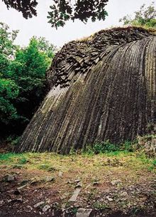
Sights include the castles of Fiľakovo , Hajnáčka and Šomoška (near Šiatorská Bukovinka ). At the last-mentioned castle there is the so-called stone waterfall, a formation of pentagonal and hexagonal columnar basalt beams (see picture). You can also find volcanic cones, volcanic vents and rock seas in the mountains.
Web links
Coordinates: 48 ° 12 ′ 0 ″ N , 19 ° 54 ′ 0 ″ E

