Protected landscape area Cerová vrchovina
| Protected landscape area Cerová vrchovina Chránená krajinná oblasť Cerová vrchovina |
||
|---|---|---|
| Cerová vrchovina | ||
|
|
||
| Location: | Banskobystrický , Slovakia | |
| Next city: | Fiľakovo , Rimavská Sobota | |
| Surface: | 167.71 km² | |
| Founding: | October 10, 1989 | |
| Address: | Správa CHKO Cerová vrchovina Železničná ul. 31 979 01 Rimavská Sobota |
|
The Protected Landscape Area Cerová vrchovina ( Slovak Chránená krajinná oblasť Cerová vrchovina ) is a protected landscape area in the southern center of Slovakia . It covers a large part of the Cerová vrchovina ("Turkey oak mountains"), which belongs to the Western Carpathians . The area lies entirely in the political district of Banskobystrický kraj (Okresy Lučenec and Rimavská Sobota ) and covers an area of 167.71 km².
The administrative headquarters are in Rimavská Sobota . The protected landscape area was proclaimed in 1989 and the relevant law was changed in 2001.
geography
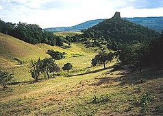
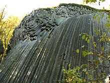
The protected landscape area is located in southern Slovakia on the Slovak-Hungarian border. The boundaries do not include the entire mountainous area, but only the most valuable parts and avoid built-up areas, with the exception of the municipalities of Šiatorská Bukovinka and Hajnáčka . Cerová vrchovina is an extinct volcanic mountain range, the formation of which is dated to the Pliocene and Pleistocene ages . Before that, towards the end of the Tertiary, there were eruptions of the basalt volcanoes, which lasted until the older Quaternary, with lava, ash and other products of volcanism filling the valleys. Then there was a relief reversal , i.e. H. the former mountain ridges became valleys and the valleys covered by volcanic rocks created new ridges. You can still see volcanic cones (Ragáč), volcanic vents (Hajnáčsky hradný vrch, Soví hrad), lava carpets and streams (Pohanský hrad, Medveš) that have changed due to erosion processes. At Šomoška Castle (Šiatorská Bukovinka municipality) there is a basalt formation, the so-called stone waterfall, a series of pentagonal and hexagonal basalt beams.
The Ipeľ and Rimava rivers drain the area. The highest peaks are the Karanč ( 725 m nm ) and Šiator ( 660 m nm ).
Flora and fauna
Forests cover about 60% of the protected landscape area. Due to the warm climate, which extends from the Pannonian Basin in Hungary to here, predominantly heat-loving species such as sessile oak , summer oak and Turkey oak grow . Beeches grow on the colder northern slopes . To date, more than 1,250 plant species are known, divided into forest and rock species. Some protected species are e.g. B. the black meadow pasque flower , crown light carnation , dwarf iris , yellow bladder bush , golden beard grass and several species of the feather grass genus .
The area belongs to the forest steppe and steppe zone, so the area is rich in many species of butterflies ( sail butterfly and swallowtail ) and beetles (such as nine species of ground beetles and stag beetles ). In the dry layers of several types of reptiles, such as live Eastern Green lizard , wall lizard , blindworm or Schlingnatter . Numerous species of birds can be found especially around the Hostice reservoir . In the underground areas of some bat species, such as live lesser horseshoe bat , Barbastelle and Noctule .
Special nature protection
- Národné prírodné rezervácie (NPR, National Nature Reserves)
- Pohanský hrad (222.54 ha, since 1964)
- Ragáč (9.73 ha, 1964)
- Šomoška (36.62 ha, 1954)
- Národné prírodné pamiatky (NPP, National Natural Monuments)
- Kostná dolina (4.92 ha, since 1994)
- Prírodné pamiatky (PP, natural monuments)
- Belinské skaly (7.11 ha, since 1993)
- Čakanovský profile (0.69 ha, 1990)
- Jalovské vrstvy (1.7 ha, 1988)
- Lipovianske pieskovce (0.13 ha, 1990)
- Soví hrad (2.81 ha, 1964)
- Záboda (20.72 ha, 1999)
- Prírodné rezervácie (PR, nature reserves)
- Hajnáčsky hradný vrch (9.71 ha, since 1964)
- Ostrá skala (17.79 ha, 2001)
- Steblová skala (37.92 ha, 2000)
- Chránené areály (CHA, Protected Areas)
- Fenek (9.68 ha, since 1993)
- Vinohrady (35.79 ha, 1999)
Source:
literature
- Ján Lacika, Kliment Ondrejka: Prírodné Krásy Slovenska - Chránené krajinné oblasti . Ed .: DAJAMA. 1st edition. Bratislava 2009, ISBN 978-80-89226-29-0 .


