Pienines National Park (Slovakia)
| Pieniny National Park Pieninský národný park |
||
|---|---|---|
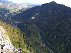
| The Dunajec breakthrough in Pieniny | ||
|
|
||
| Location: | Prešovský , Slovakia | |
| Specialty: | smallest national park in Slovakia | |
| Next city: | Spišská Stará Ves | |
| Surface: | 37.49 km² | |
| Founding: | January 16, 1967 | |
| Address: | Správa Pieninského národného parku č. 73 059 06 Červený Kláštor www.pienap.sk |
|
The Pieninen National Park ( Slovak Pieninský národný park , abbreviation PIENAP) is a national park in Slovakia . It covers the Slovak side of the Pieninen Mountains (Pieniny in Slovak) and is the smallest of the nine Slovak national parks with an area of 37.49 km². However, the size of the protection zone is 223.68 km² and covers a large part of the Zamagurie region . The park was founded on January 16, 1967 and connects to the national park on the Polish side , which was founded in the 1930s . The administrative seat is in the municipality of Červený Kláštor .
The national park is located in the political district of Prešovský kraj in the Okresy Kežmarok and Stará Ľubovňa in the traditional Spiš landscape . The highest mountain is the Vysoké skalky ( 1050 m nm ) on the border near Lesnica. In the Dunajec breakthrough valley stands the Holica ( 828 m nm ); it is somewhat lower than the famous Trzy Korony mountain ( 982 m nm ) on the Polish side.
The most famous attraction of the park is the border river Dunajec , which runs through the Pieninen in a breakthrough valley. There are many opportunities for hiking there. There is rafting on the river . Shortly before the outflow of the Dunajec into Polish territory, the Lesnický creek flows into a valley that is almost 300 meters deep.
But the national park also has something to offer in terms of cultural landscape. The Červený Kláštor monastery (German Red Monastery) in the municipality of Červený Kláštor, a former Carthusian, later Camaldolese monastery, is now a museum. The municipality of Lesnica is a gateway to the national park. Further to the west in the protection zone is the Goral village of Osturňa , which has been declared a folk architecture reserve due to the many preserved Goral buildings.
Of the specially protected areas, after a new zoning into four zones in 2004, only the national natural monument Aksamitka (since 1979), a karst cave, remained. The following areas were specially protected until the dissolution:
- Národné prírodné rezervácie (NPR, National Natural Monuments)
- Haligovské skaly (63.11 ha, 1967-2004)
- Prielom Dunajca (360.15 ha, 1967-2004)
- Prielom Lesnického potoka (31.87 ha, 1967-2004)
- Prírodné rezervácie (PR, nature reserves)
- Kamienska tisina (20.27 ha, 1996-2004)
Since 2004, an area of 13.01 km² has been part of the Natura 2000 areas (code: SKUEV0337 ).
literature
- Ján Lacika, Kliment Ondrejka: Prírodné Krásy Slovenska - Národné parky . Ed .: DAJAMA. 1st edition. Bratislava 2009, ISBN 978-80-89226-27-6 .
Web links
- Official site of the administration (Slovak)


