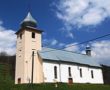
Osturňa
| Osturňa | ||
|---|---|---|
| coat of arms | map | |

|
|
|
| Basic data | ||
| State : | Slovakia | |
| Kraj : | Prešovský kraj | |
| Okres : | Kežmarok | |
| Region : | Tatry | |
| Area : | 41.237 km² | |
| Residents : | 311 (Dec. 31, 2019) | |
| Population density : | 8 inhabitants per km² | |
| Height : | 717 m nm | |
| Postal code : | 059 79 | |
| Telephone code : | 0 52 | |
| Geographic location : | 49 ° 20 ' N , 20 ° 15' E | |
| License plate : | KK | |
| Kód obce : | 523771 | |
| structure | ||
| Community type : | local community | |
| Administration (as of November 2018) | ||
| Mayor : | Kristína Gregoričková | |
| Address: | Obecný úrad Osturňa 153 05972 Osturňa |
|
| Website: | www.osturna.obce.info | |
| Statistics information on statistics.sk | ||
Osturňa (German Asthorn , Hungarian Osztornya - until 1902 Oszturnya ) is a municipality in northern Slovakia , through which a brook flows into the Dunajec . It is located at the northern foot of the Spiš Magura near the Polish border, about 17 km from Spišská Stará Ves and 60 km from Poprad .
The place was first mentioned in writing in 1593. A minority of the Gorals live in the village . Many buildings that are exemplary of the typical Goral culture have been preserved, which is why the place is a folk architecture reserve.
Web links
Commons : Osturňa - collection of pictures, videos and audio files

