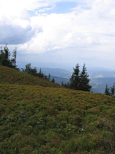
Kysuce Protected Landscape Area
| Kysuce Chránená krajinná oblasť Kysuce protected landscape area |
||
|---|---|---|
| Veľká Rača | ||
|
|
||
| Location: | Žilinský , Slovakia | |
| Next city: | Bytča , Čadca , Krásno nad Kysucou , Turzovka | |
| Surface: | 654.62 km² | |
| Founding: | May 23, 1984 | |
| Address: | Správa CHKO Kysuce U Tomali 1511 022 01 Čadca |
|
The Kysuce Protected Landscape Area ( Slovak Chránená krajinná oblasť Kysuce ) is a protected landscape area in northwestern Slovakia , which is located in the traditional Kysuce landscape , and consists of two separate parts. The area is mainly in the political district of Žilinský kraj (Okresy Bytča , Čadca , Dolný Kubín and Žilina ), with smaller parts in Trenčiansky kraj (Okresy Považská Bystrica and Púchov ). The landscape protection area borders on the Czech landscape protection area Beskydy , the Polish landscape protection park Saybusch and the Slovak landscape protection area Horná Orava .
The administrative seat is in Čadca .
geography
The protected landscape area is located in the Kysuce region north and northwest of Žilina and is made up of two different parts. However, the whole area lies in the outer Western Carpathians and is formed by flysch rock . The western part is in the Javorníky and Moravian-Silesian Beskids Mountains and in the Turzovská vrchovina Mountains and touches the Czech-Slovakian border. The highest mountain is Veľký Javorník ( 1071 m nm ). The eastern part lies in the Beskydy Mountains and is taken up by the Kysucké Beskydy and Kysucká vrchovina mountains ; he touches the Slovak-Polish border. The highest point is the Veľká Rača ( 1236 m nm ).
As a result of the late medieval Wallachian colonization, the area has a mosaic character, with alternating small settlements with old folk architecture as well as meadows, fields and forests.
The area belongs to the catchment area of the Waag , mostly fed by the tributary Kysuca . Only in the Javorník Mountains do some of the streams flow directly into the Waag. Due to the impermeable flysch rock and the relatively advanced deforestation , the runoff is relatively fast, which can sometimes lead to local flooding.
Flora and fauna
Compared to the other extensive Slovak nature reserves, the area of the CHKO Kysuce is relatively little forested with around more than 50%. Oaks are very rare, but beech and artificially introduced spruce monocultures are dominant. The original mixed forests are only found in the higher-lying border areas. The area is home to several peat and bog localities, where plants such as round-leaved sundew , ostrich fern , Turkish league and common columbine as well as many from the orchid family grow.
To date, more than 200 species of vertebrates are known. The western border of the distribution of large carnivores of Slovakia - brown bear , wolf and lynx - runs through the area . A Carpathian endemic is the Carpathian Newt .
tourism
Some attractions in the area of CHKO Kysuce are the Korňa oil well , sandstone spheres such as those near Klokočov , the Vychylovka forest railway with switchbacks over the Beskydy Mountains and the nearby Kysuce Village Museum , an open-air museum ( Nová Bystrica municipality ).
Special nature protection
The following more specific protected areas can be found in the large protected area:
-
Národné prírodné rezervácie (NPR, National Nature Reserves)
- Malý Polom (86.1 ha, since 1981)
- Veľká Rača (313.0 ha, 1976)
- Veľký Javorník (13.95 ha, 1967)
-
Prírodné pamiatky (PP, natural monuments )
- Korniansky ropný prameň (0.171 ha, since 1973)
- Vychylovské prahy (0.383 ha, 1973)
- Vychylovské skálie (26.72 ha, 1983)
-
Prírodné rezervácie (PR, nature reserves)
- Čertov (84.62 ha, since 1993)
- Čierna Lutiša (26.35 ha, 1962)
- Hričovec (21.12 ha, 1988)
- Javorinka (35.52 ha, 1993)
- Klokočovské skálie (6.12 ha, 1973)
- Klubinský potok (0.826 ha, 2000)
- Polkova (5.08 ha, 1993)
- Veľký Polom (47.58 ha, 1993)
- Zajačkova lúka (3.98 ha, 1979)
-
Chránené areály (CHA, Protected Areas)
- Chmúra (0.409 ha, 2001)
- such as:
- Beskydy Dark Sky Park ( light protection area , cross-border with the Czech Republic 31,000 ha, since 2013)
literature
- Ján Lacika, Kliment Ondrejka: Prírodné Krásy Slovenska - Chránené krajinné oblasti . Ed .: DAJAMA. 1st edition. Bratislava 2009, ISBN 978-80-89226-29-0 .
Individual evidence
- ↑ Štátny zoznam osobitne chránených častí prírody SR , uzemia.enviroportal.sk


