
Javorník Mountains
| Javorník Mountains | ||
|---|---|---|
| Highest peak | Veľký Javorník ( 1071 m nm ) | |
| location | Slovakia , Czech Republic | |
| part of | Western Carpathians | |
|
||
| Coordinates | 49 ° 15 ′ N , 18 ° 30 ′ E | |


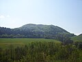
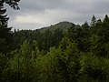
The Javorník Mountains , (Czech, Slovak Javorníky ) is a mountain range in the Western Carpathians that forms part of the border between the Czech Republic and Slovakia . The highest point is the Veľký Javorník with an altitude of 1071 meters. The highest mountain on the Czech side is the Malý Javorník (1019 m nm). Other prominent peaks are the Lemešná massif (950 m nm) in the north and the Makyta (923 m nm) in the south . The elevation separates the Bečva - Oder river basin from the Kysuca - Waag basin and is thus part of the European watershed .
To the south, the Lisbon Pass forms the natural border with the White Carpathians . In the northwest, the Senice valley separates the Javorníky from the Vsetínské vrchy .
Much of the mountains in Slovakia are located in the Kysuce Protected Landscape Area .
gallery
Hradište

Velký Javorník (German: Großer Ahornberg )
Makyta ( Makita )
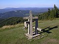
Stratenec mountain with memorial to the fallen from World War II


