Slovak Paradise National Park
| Slovak Paradise National Park Národný park Slovenský raj |
||
|---|---|---|
| Stratenská píla | ||
|
|
||
| Location: | Košický , Prešovský , Slovakia | |
| Next city: | Spišská Nová Ves , Dobšiná , Poprad | |
| Surface: | 197.63 km² | |
| Founding: | January 18, 1998 | |
| Address: | Sprava Národného parku Slovenský raj Letecká 3 052 01 Spišská Nová Ves |
|
The Slovak Paradise National Park ( Slovak Národný park Slovenský raj ) is a Slovak national park in the east-center of the country. It extends over part of the Slovak Ore Mountains , in the mountains of the same name , which belong to the Spišsko-gemerský kras .
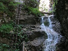
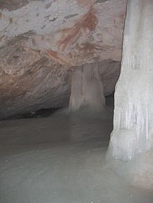
The park is 197.63 km², its protection zone covers an area of 130.11 km², a total of 327.74 km². The majority is in the political district of Košický kraj (Okresy Rožňava and Spišská Nová Ves ). Smaller parts are in Prešovský kraj ( Okres Poprad ) and a tiny part (near Telgárt ) in Banskobystrický kraj ( Okres Brezno ). Marked hiking trails with a total length of about 300 km run through the area, often equipped with ladders, chains and bridges, in a charming landscape over deep gorges and in the immediate vicinity of the waterfalls. Some parts are also protected in eleven national nature reserves and seven nature reserves. There are also more than 200 caves, but only one is open to the public as a show cave: the Dobschauer Ice Cave , since 2000 part of the UNESCO World Heritage "Caves of the Slovak Karst and Aggtelek Karst".
The administrative seat is in Spišská Nová Ves . A 156.96 km² area within the national park has been listed as a Natura 2000 area since 2004 (code: SKUEV0112 ).
History and name
The predecessor of the park was founded in 1964 and was classified as a landscape protection area (Slov. Chránená krajinná oblasť , CHKO). It was the first ever CHKO in Slovakia. On January 18, 1988 he received by regulation of the government of the SSR 23/1988 Zb. the status of a national park. The name "Slovak Paradise" appeared for the first time in 1921 in the magazine Krásy Slovenska , before the mountains had different names, such as the limestone mountains of Hrabušice ( Kabsdorf ) / Letanovce ( Lettensdorf ), Vernár-Hnilec mountains, Stratená ( lost soaps ) and others . Ä.
geography
The national park is located in eastern Slovakia . Geomorphologically it belongs to the Slovak Ore Mountains, lower part Spišsko-gemerský kras, which also includes the Slovak Paradise. Cities in the immediate vicinity are Spišská Nová Ves , Dobšiná and Poprad , important municipalities are Dedinky , Hrabušice , Mlynky , Stratená and Vernár . The core zone covers most of the mountain range, while the protection zone includes part of the Hornádska kotlina basin in addition to the rest . In the west the park borders on the Low Tatras , in the south on the Volovské vrchy .
Larger rivers are the Hnilec in the south and the Hornád in the north. There are also streams such as Biely potok , Veľká Biela voda , Vernársky potok or Zajf . The park is known for a large number of canyons that are up to 300 meters deep. The best known are Veľký Sokol , which is also the longest at 4.5 km, Suchá Belá , Piecky and Kyseľ , all with numerous waterfalls. The longest breakthrough valley is called Prielom Hornádu (German breakthrough valley of Hornád), which is 11 to 16 km long and up to 150 meters deep, depending on the source. The highest waterfall is Závojový vodopád (70 m). In addition to the publicly accessible gorges, there are also a number of closed gorges. This was done for reasons of increased nature conservation in order to leave some areas untouched. On the southern edge there is the Palcmanská Maša reservoir (56 hectares), which is used for various leisure activities, but also for fishing.
The highest mountain is the Predná hoľa ( 1545 m nm ), other important tourist mountains are the Havrania skala (1153 m nm) and Tomášovský výhľad (680 m nm). The lowest point is on Hornád with 470 m nm near Smižanská Maša.
Flora and fauna
The varied landscape is also reflected in the rich flora and fauna. The national park has the largest variety of butterflies in Slovakia, with 6.06 species per square kilometer. On the Kopanecké lúky meadow , the variety of higher vascular plants is up to 75 species per square meter.
In the national park there are about 4000 species of invertebrates, including about 2000 species of butterflies, 400 species of beetles and 150 species of molluscs. Vertebrates are represented with more than 200 species; The most famous mammals include the brown bear , fox , wolf , wild cat , deer , wild boar and marten . Numerous gorges and dense forests are home to different species of birds, whether birds of prey or songbirds.
Forests cover about 90% of the area of the national park. For the most part beech, fir, spruce and pine grow there. There are around 930 plant species in the park, around 30 of which are protected. 6 species are endemic to the Slovak Paradise, another 19 species only occur in the Western Carpathians . These include: Slavic pasque flower ( Pulsatilla slavica ), large-flowered foxglove ( Digitalis grandiflora Mill. ), Carpathian bellflower ( Campanula carpatica ). Due to climatic characteristics, species that are normally only found in the high mountains, such as mountain pine , edelweiss or Swiss moss fern , also grow here .
Special nature protection
Some areas within the national park are specially protected. These are:
- Národné prírodné rezervácie (NPR, National Nature Reserves)
- Hnilecká jelšina (84.59 ha, since 1988)
- Holý kameň (210.87 ha, 1976)
- Kyseľ (949.97 ha, 1964)
- Piecky (244.93 ha, 1964)
- Prielom Hornádu (290.49 ha, 1964)
- Sokol (700.93 ha, 1964)
- Stratená (698.87 ha, 1976)
- Suchá Belá (153.52 ha, 1964)
- Tri Kopce (246.23 ha, 1984)
- Vernárska tiesňava (82.94 ha, 1966)
- Zejmarská roklina (72.65 ha, 1980)
- Národné prírodné pamiatky (NPP, National Natural Monuments)
- Dobšinská ľadová jaskyňa (360.21 ha, since 1964)
- Medvedia jaskyňa (1972)
- Stratenská jaskyňa (2001)
- Prírodné pamiatky (PP, natural monuments)
- Hranovnické pleso (68.09 ha, since 1984)
- Prírodné rezervácie (PR, nature reserves)
- Barbolica (11.97 ha, since 1988)
- Čingovské hradisko (44.02 ha, 1982)
- Kocúrová (16.72 ha, 1974)
- Malé Zajfy (7.24 ha, 1993)
- Mokrá (60.2 ha, 1966)
- Ostrá skala (6.66 ha, 1976)
- Vyšná Roveň (6.98 ha, 1993)
literature
- Ján Lacika, Kliment Ondrejka: Prírodné Krásy Slovenska - Národné parky . Ed .: DAJAMA. 1st edition. Bratislava 2009, ISBN 978-80-89226-27-6 .
Web links
- Short entry on Slovak Paradise on sopsr.sk (Slovak)
- Tourist information (German)


