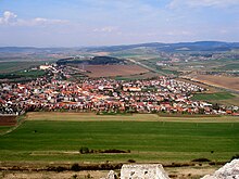
Hornádska kotlina
The Hornádska kotlina (German about "Hornád valley basin") is a geomorphological unit of the Fatra-Tatra region in the Inner Western Carpathians in the eastern part of Slovakia .
Going clockwise, the valley adjacent to the levoča mountains ( Levočské vrchy ) in the north, mountains Branisko and Čierna hora in the east, Volovské vrchy and Spiš-Gemer Karst in the south (the last three mountain ranges are also part of the Slovak Ore Mountains ), to the Low Tatra Mountains ( Nízke Tatry ) and Kozie chrbty in the west and the Podtatranská kotlina basin in the northwest. The border to Podtatranská kotlina is in the village of Jánovce . The highest point is the Kačelák mountain ( 677.3 m nm ).
The Hornádska kotlina is divided into four further sub-units:
- Vikartovská Priekopa ( "digging Vikartovce ")
- Hornádske podolie ("Hornád valley landscape")
- Medvedie chrbty ("bear back")
- Podhradská kotlina (" Podhradie Cauldron ")
The Hornád river , which gives it its name, flows through the southern edge of the basin, the most important left tributaries of which are the Levočský potok and the Margecianka . The Hornádska kotlina is important because of the largest travertine deposits in Slovakia. Seven travertine hills have formed around the town of Spišské Podhradie: Dreveník , Sivá Brada , Sobotisko , Pažica , Spišský hradný vrch , Ostrá hora and Kamenec .
The basin is the core of the historical Spiš landscape , with historical towns such as Spišská Nová Ves , Levoča , Spišské Podhradie and Spišské Vlachy . It is heavily used for agriculture, with only remnants of the formerly widespread forests. Today the Hornádska kotlina is divided between the administrative units Prešovský kraj in the north and Košický kraj in the south. In terms of traffic, east-west connections are important: part of the double- track Košice – Žilina railway (formerly Kaschau-Oderberger Bahn ) lies in the south , while state road 18 runs in the north . The D1 motorway , which is completely finished in this area, runs parallel to this .
literature
E. Mazúr, M. Lukniš: Geomorfologické členenie SSR and ČSSR. Časť Slovensko . Slovenská kartografia, Bratislava 1986.

