Hrabušice
| Hrabušice | ||
|---|---|---|
| coat of arms | map | |

|
|
|
| Basic data | ||
| State : | Slovakia | |
| Kraj : | Košický kraj | |
| Okres : | Spišská Nová Ves | |
| Region : | Spiš | |
| Area : | 40.886 km² | |
| Residents : | 2,536 (Dec. 31, 2019) | |
| Population density : | 62 inhabitants per km² | |
| Height : | 548 m nm | |
| Postal code : | 053 15 | |
| Telephone code : | 0 53 | |
| Geographic location : | 48 ° 59 ′ N , 20 ° 25 ′ E | |
| License plate : | SN | |
| Kód obce : | 526592 | |
| structure | ||
| Community type : | local community | |
| Administration (as of November 2018) | ||
| Mayor : | Jana Skokanová | |
| Address: | Obecný úrad Hrabušice Hlavná ulica 171 053 15 Hrabušice |
|
| Website: | www.hrabusice.sk | |
| Statistics information on statistics.sk | ||
Hrabušice (until 1927 also Hrabošice in Slovak ; German Kabsdorf - older also Kapsdorf or Kalbsdorf , Hungarian Káposztafalva - until 1907 Káposztafalu ) is a municipality in eastern Slovakia .
geography
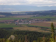
The municipality is located in the historical Spiš region in the western part of the Hornád basin ( Hornádska kotlina ), on the bank of the Hrabušice brook , which flows into the Hornád not far from the village . The village center is 548 meters above sea level. The place is located on the northern slopes of the Slovak Paradise and is the starting point for some natural attractions. Larger towns nearby are Poprad (in the northwest) and Spišská Nová Ves (in the southeast), both 16 km away. The next rail connection is in the neighboring village of Vydrník (3 km north) on the Košice – Žilina railway line .
history
The first documented settlement took place at the end of the Latène period ; there was also a settlement of the Puchau culture from Roman times . The first written mention of the place was in 1279 as villa Composita . He later belonged to the Confederation of the Spiš Saxons and from 1465 to the rule of the Spis Castle . There was a brewery, a sawmill, a mill and a steel mill in the village. The population engaged in agriculture and hunting.
Attractions
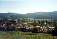
- Roman Catholic Church of St. Lawrence from the middle of the 13th century, originally in the Romanesque style. Inside there is a winged altar from the years 1516–1520 from the workshop of Paul von Leutschau .
- Catholic rectory from the 17th century, originally in the Renaissance style, today in the Baroque style
- Remains of the Marcelov hrad castle on Zelená hora ( 654 m nm , literally Green Mountain ), which was built in the 13th century and destroyed by the citizens of Levoča in 1462
- Remains of the Kláštorisko Monastery on the Refuge Rock (Skala útočišťa), which was built by Carthusians in 1299 and destroyed in the 16th century
- Natural sights in the Slovak Paradise, including the Suchá Belá, Prielom Hornádu, Kláštorská roklina , Veľký Sokol and Piecky gorges . The former can be reached from Podlesok , the latter from Píla .
population
According to the 2001 census, of 2173 inhabitants, 1814 were Slovaks (83.5%) and 348 were Roma (16%). In 1992 the population (91.7%) stated that their denomination was Roman Catholic .


