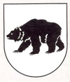
Iliašovce
| Iliašovce | ||
|---|---|---|
| coat of arms | map | |

|
|
|
| Basic data | ||
| State : | Slovakia | |
| Kraj : | Košický kraj | |
| Okres : | Spišská Nová Ves | |
| Region : | Spiš | |
| Area : | 13,492 km² | |
| Residents : | 1,000 (Dec. 31, 2019) | |
| Population density : | 74 inhabitants per km² | |
| Height : | 522 m nm | |
| Postal code : | 053 11 | |
| Telephone code : | 0 53 | |
| Geographic location : | 49 ° 0 ' N , 20 ° 32' E | |
| License plate : | SN | |
| Kód obce : | 543161 | |
| structure | ||
| Community type : | local community | |
| Administration (as of November 2018) | ||
| Mayor : | Anna Frankovičová | |
| Address: | Obecný úrad Iliašovce č. 231 053 11 Iliašovce |
|
| Website: | www.iliasovce.obecnyurad.eu | |
| Statistics information on statistics.sk | ||
Iliašovce (until 1927 Slovak also Iľašovce ; German Sperndorf or Selgersdorf , Hungarian Illésfalva - until 1907 Illésfalu , Latin Villa Sperarum is a municipality in) east of Slovakia of 1000 inhabitants (December 31, 2019) and is part of the Spišská Nová Ves District , a Part of the Košický kraj , as well as the traditional Spiš landscape .
geography
The village is located in the northern part of the Hornádska kotlina basin by the Iliašovský brook . The center of the village lies at an altitude of 522 m nm and is seven kilometers from Spišská Nová Ves and eight kilometers from Levoča .
Iliašovce is the northernmost municipality of Košický kraj.
history
The place was mentioned in writing for the first time in 1263 as "Villa Ursi" (place of the bear). This fact is reflected in the municipal coat of arms, which shows a black bear. Already in 1282 the documents mention "Helyasasa", which refers on the one hand to the name of the county count ( comes ) Elias, on the other hand to the German colonization ("Zipser Sachsen") of the Spiš after the Mongol invasion in 1241. In the Middle Ages Iliašovce was part of a free city the province of the 24 Spiš cities. After the 13 Spiš cities were leased by Poland in 1412, the place remained with the Kingdom of Hungary as part of the 11 Spiš cities, but in 1465 it finally became the property of the Spis Castle .
From the beginning of the 16th to the beginning of the 18th century the place fell into disrepair due to constant revolts in the area; In 1605 the whole village fell victim to a fire. Religious disputes between the Catholic and Protestant Churches contributed to the decline.
The last sovereign before the abolition of serfdom in 1848 was the Csáky family. By the end of the 19th century the population had largely become Slovak; according to data from 1880, of 586 inhabitants, 3 were Germans, 21 Magyars and all other Slovaks.
Until 1918, the place in Zips County belonged to the Kingdom of Hungary and then came to Czechoslovakia , now Slovakia.
In November 2012, part of the Diaľnica D1 motorway bridge near Iliašovce, which was under construction, collapsed, killing four people.
population
Results of the 2001 census (962 inhabitants):
|
By ethnicity:
|
By denomination:
|
Attractions
- Roman Catholic Church from 1770.
- Protestant church from 1927.
- Ruins of a pleasure palace called Sans Souci , built in 1770, demolished in 1803
