Arnutovce
| Arnutovce | ||
|---|---|---|
| coat of arms | map | |

|
|
|
| Basic data | ||
| State : | Slovakia | |
| Kraj : | Košický kraj | |
| Okres : | Spišská Nová Ves | |
| Region : | Spiš | |
| Area : | 2.228 km² | |
| Residents : | 809 (Dec. 31, 2019) | |
| Population density : | 363 inhabitants per km² | |
| Height : | 520 m nm | |
| Postal code : | 053 13 ( Letanovce Post Office ) | |
| Telephone code : | 0 53 | |
| Geographic location : | 48 ° 59 ' N , 20 ° 30' E | |
| License plate : | SN | |
| Kód obce : | 526363 | |
| structure | ||
| Community type : | local community | |
| Administration (as of November 2018) | ||
| Mayor : | Zuzana Toporcerová | |
| Address: | Obecný úrad Arnutovce č. 64 053 13 Letanovce |
|
| Website: | www.arnutovce.ocu.sk | |
| Statistics information on statistics.sk | ||
Arnutovce (until the 19th century Slovak "Harnutovce"; German Höfchen , older Habchen or Emaus , Hungarian Arnótfalva - until 1907 Arnótfalu ) is a municipality in the east of Slovakia with 809 inhabitants (December 31, 2019) and belongs to Okres Spišská Nová Ves , part of the Košický kraj and the traditional Spiš landscape .
geography
The municipality is located in the western part of the Hornádska kotlina basin in the Hornád catchment area . The municipality is small with about 2.23 km² and covered by brown forest floors. The center of the village is at an altitude of 520 m nm and is seven kilometers from Spišská Nová Ves .
Neighboring municipalities are Spišský Štvrtok in the west and north, Iliašovce in the east and Smižany in the southeast.
history
A royal village called Kistamási (Slovak equivalent of Malé Tomášovce ) stood at the location of today's Arnutovce municipality around 1200 , which was donated to Spiš Provosty in 1259 by King Béla IV and in 1278 became the estate of a certain Arnold . The current place was first mentioned in writing in 1317 as terra magni Arnoldi . In 1366 the village came under the ownership of the Carthusian monastery on the Refuge Rock (located in today's Slovak Paradise ), after its dissolution in 1543 it became king again and was finally donated to the Spiš Chapter in 1550. In 1787 the village had 19 houses and 139 inhabitants; In 1828 there were 22 houses and 181 inhabitants who lived mainly from agriculture.
Until 1918 the place in Zips County belonged to the Kingdom of Hungary and then came to Czechoslovakia or now Slovakia.
population
According to the 2011 census, there were 698 inhabitants in Arnutovce, of which 679 were Slovaks and 7 were Roma. There is no information on ethnicity for 12 inhabitants.
632 residents professed to the Roman Catholic Church, 17 residents to the Greek Catholic Church, 4 residents to the Evangelical Church AB and 1 resident to the Orthodox Church. 31 residents had no denomination and the denomination of 13 residents was not determined.
Buildings
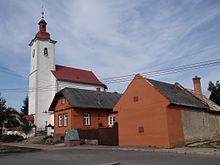
- Roman Catholic Helenenkirche in Gothic style from the 15th century, with the Renaissance tower built in the second half of the 16th century. The winged altar dates from around 1485 and is probably the work of master Martin von Leutschau.
traffic
Arnutovce is located on a junction of the 2nd order road 536 between Spišský Štvrtok and Spišská Nová Ves. There is a connection to the 1st order road 18 ( E 50 ) and thus to the trunk road network in Spišský Štvrtok, four kilometers away.
The nearest rail connection is the Spišské Tomášovce stop on the Košice – Žilina railway line . There is a connection to high-speed trains and some IC trains at Spišská Nová Ves train station, seven kilometers away.
Individual evidence
Web links
- Entry on e-obce.sk (Slovak)


