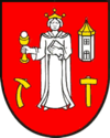
Krompachy
| Krompachy | ||
|---|---|---|
| coat of arms | map | |

|
|
|
| Basic data | ||
| State : | Slovakia | |
| Kraj : | Košický kraj | |
| Okres : | Spišská Nová Ves | |
| Region : | Spiš | |
| Area : | 22.889 km² | |
| Residents : | 8,684 (Dec. 31, 2019) | |
| Population density : | 379 inhabitants per km² | |
| Height : | 379 m nm | |
| Postal code : | 053 42 | |
| Telephone code : | 0 53 | |
| Geographic location : | 48 ° 55 ' N , 20 ° 52' E | |
| License plate : | SN | |
| Kód obce : | 543268 | |
| structure | ||
| Community type : | city | |
| Administration (as of November 2018) | ||
| Mayor : | Iveta Rušinová | |
| Address: | Mestský úrad Krompachy námestie Slobody 1 05342 Krompachy |
|
| Website: | www.krompachy.sk | |
| Statistics information on statistics.sk | ||
Krompachy (German Krompach , older also Krombach ; Hungarian Korompa ) is a city in Eastern Slovakia with 8,684 inhabitants (as of December 31, 2019).
geography
Krompachy is located in the traditional Spiš region . Geographically, the city is located in the Slovak Ore Mountains on the right bank of the Hornád . The built-up area extends on both sides of the Hornád tributary Slovinský potok . The Branisko Mountains rise north of the city . The city center is located at an altitude of 379 m nm and is 28 kilometers from Spišská Nová Ves and 45 kilometers from Košice .
In addition to the main town Krompachy, the municipality has a district called Zemianska Strana (German noble hut ).
Neighboring municipalities are Kaľava in the north, Richnava in the northeast, Kluknava in the east, Žakarovce in the southeast, Gelnica and Slovinky in the south, Spišské Vlachy in the southwest and Kolinovce in the west.
history
Krompachy was mentioned in writing for the first time in 1282 in a document from King Ladislaus IV and at that time belonged to the estate of Spiš Castle . As early as the 14th century there is evidence of copper trade, market rights and the like, but the development was constantly slowed down by constant wars or arguments. According to an agreement with the then landlord in 1602, subordinate labor was replaced by tax payments and the city has since been regarded as a Royal Free City.
The city was industrialized in the 19th century, with the construction of an iron and roller mill in 1841. The city peaked at the turn of the 19th and 20th centuries, when the ironworks had 3,500 employees and was the largest ironworks in the kingdom at that time Hungary , with production of 85,000 tons of pig iron and 100,000 tons of steel per year.
After the break-up of Austria-Hungary and its integration into Czechoslovakia , growth came to a standstill, influenced by the political conflicts and the economic crisis after the First World War. The uprising in Krompachy ( Krompašská vzbura in Slovak ) on February 21, 1921, which ended in a bloody army shootout and left four dead and 14 injured, is particularly well-known . The ironworks was liquidated in 1923. The copper works built in 1937 were destroyed during the Second World War, but restored in 1951, together with the electrotechnical works built in 1948.
In recent years tourism has developed alongside the two existing industrial companies. The winter sports area Plejsy should be mentioned here.
population
Results after the 2001 census (8812 inhabitants):
|
By ethnicity:
|
By religion:
|
Attractions
- Roman Catholic church in the baroque-classical style from 1774
- Protestant church in the pseudo-Gothic style
- baroque-classical country castle
- Hammer mill building in Stará Maša
- Blast furnace from 1832
economy
Krompachy is the headquarters of the copper smelter Kovohuty, as, which employed around 150 people in 2019. It is a subsidiary of the Austrian Montanwerke Brixlegg AG .
Other industrial companies include the foundry Zlieváreň SEZ Krompachy and the electrical engineering company SEZ Krompachy .
traffic
The city has a train station on the Košice – Žilina railway line . The country road II / 547 (Košice - Margecany - Spišské Vlachy ) runs through the village .
Town twinning
-
 Békéscsaba , Hungary
 -
 Gaszowice , Poland
 -
 Nădlac , Romania
 -
 Rýmařov , Czech Republic
sons and daughters of the town
- Ludwig von Tetmajer (1850–1905), professor at the Zurich Polytechnic
- Zsolt Harsányi (1887–1943), Hungarian theater director and writer
- Bartolomej Urbanec (1918–1983), composer and conductor
- Ondrej Lenárd (* 1942), conductor
- Igor Kováč (* 1969), sprinter
- Ladislav Strompf (* 1969), ice hockey player
See also
Individual evidence
- ↑ Pred 90 rokmi vypukla krompašská vzbura , Künstne.sk, accessed on June 4, 2012


