
Okres Stará Ľubovňa
| Overview maps | |
|---|---|

|

|
| Basic information Okres Stará Ľubovňa | |
| Kraj : | Prešovský kraj |
| Area : | 707.87 km² |
| Residents : | 53,958 (December 31, 2019) |
| Population density : | 76.21 inhabitants / km² |
| License plate : | SL |
| District code: | 710 |
| Administrative division | |
| Cities: | 2 |
| Municipalities (excluding cities): | 42 |
| Statistics information about the Okres on statistics.sk | |
The Okres Stará Ľubovňa is an administrative unit in the northeast of Slovakia km² with 53,958 inhabitants (31 December 2019) and an area of 707.9.
Historically, the district is largely located in the former Zips (Spiš) county in the west of the area, a smaller part in the former Sáros county (Šariš in the east, see also the list of historical counties of Hungary ).
The okres is one of the youngest in Slovakia because it has only existed in its current form since 1968 . The altitude is between 445 and 1157 meters above sea level. The Poprad River flows through the whole area from west to east and then flows north to Poland , forming the state border between Poland and Slovakia for 30 kilometers. In Poland it flows into the second river of the Okres Stará Ľubovňa, the Dunajec , which is also a border river in the northwest of the Okres. On the banks of the Dunajec there is the Pienin National Park , which is mainly made of limestone, while the Stará Ľubovňa area is also home to flysch sandstone .
The highest peak of the Okres is Minčol in the Čergov Mountains in the east of the area.
There are also some mineral and thermal springs in Okres Stará Ľubovňa. Are known Vyšné Ružbachy and Ľubovnianske Kúpele .
Cities
- Podolínec ( Poodle )
- Stará Ľubovňa ( [Old] Lublau )
Communities
|
|
The district office is in Stará Ľubovňa .
Picture gallery

Levočské vrchy south of Stará Ľubovňa

the Poprad on the Polish border
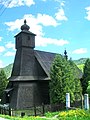
the wooden church of Hraničné
.jpg)


Culture
In the article Protected objects in the Okres Stará Ľubovňa you can find about the objects protected by the Slovak Monuments Office in the Okres.