
Plaveč (Slovakia)
| Plaveč | |||
|---|---|---|---|
| coat of arms | map | ||

|
|
||
| Basic data | |||
| State : | Slovakia | ||
| Kraj : | Prešovský kraj | ||
| Okres : | Stará Ľubovňa | ||
| Region : | Šariš | ||
| Area : | 16.682 km² | ||
| Residents : | 1,802 (Dec. 31, 2019) | ||
| Population density : | 108 inhabitants per km² | ||
| Height : | 448 m nm | ||
| Postal code : | 065 44 | ||
| Telephone code : | 0 52 | ||
| Geographic location : | 49 ° 16 ' N , 20 ° 51' E | ||
| License plate : | SL | ||
| Kód obce : | 526959 | ||
| structure | |||
| Community type : | local community | ||
| Structure of the municipality: | 3 parts of the community | ||
| Administration (as of November 2018) | |||
| Mayor : | Peter Šlosár | ||
| Address: | Obecný úrad Plaveč Hviezdoslavova 101/4 06544 Plaveč |
||
| Website: | www.plavec.sk | ||
| Statistics information on statistics.sk | |||

Plaveč (1927 to 1948 in Slovak "Plaveč nad Popradom"; German Plautsch , Hungarian Palocsa ) is a municipality in northeastern Slovakia . It is located on the Poprad River at the foot of the Ľubovnianska vrchovina mountain range , about 9 km from the Polish border and 15 km from Stará Ľubovňa .
The place was first mentioned in writing in 1269. It has a station on the Poprad – Plaveč railway line and is a railway junction.
In addition to the main town, the municipality also includes the settlements Pastovník and Podzámok and, unofficially, Závada (incorporated after 1808). From 1877 to 1957 today's neighboring village Ďurková was also part of the municipality.
Attractions
- Plaveč castle ruins
- Roman Catholic Church of St. Margaret
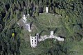


Plaveč Castle in winter
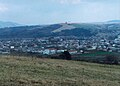
View of the place


Web links
Commons : Plaveč - collection of images, videos and audio files