Orlov
| Orlov | ||
|---|---|---|
| coat of arms | map | |

|
|
|
| Basic data | ||
| State : | Slovakia | |
| Kraj : | Prešovský kraj | |
| Okres : | Stará Ľubovňa | |
| Region : | Šariš | |
| Area : | 20.772 km² | |
| Residents : | 611 (December 31, 2019) | |
| Population density : | 29 inhabitants per km² | |
| Height : | 494 m nm | |
| Postal code : | 065 43 | |
| Telephone code : | 0 52 | |
| Geographic location : | 49 ° 17 ' N , 20 ° 52' E | |
| License plate : | SL | |
| Kód obce : | 526941 | |
| structure | ||
| Community type : | local community | |
| Structure of the municipality: | 2 parts of the community | |
| Administration (as of November 2018) | ||
| Mayor : | Peter Timočko | |
| Address: | Obecný úrad Orlov 119 06543 Orlov |
|
| Statistics information on statistics.sk | ||
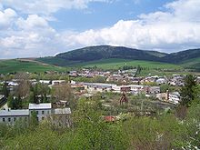
Orlov (Hungarian Orló ) is a municipality in northeast Slovakia near the border with Poland on the Poprad River.
The place was first mentioned in writing as Orlou in 1349 , but it was probably founded around 1330.
In addition to the actual place, Andrejovka , which was incorporated in 1873 and lies upstream in the east, belongs to the municipality .
Orlov is on the Kysak – Muszyna railway line .
Web links
Commons : Orlov - collection of images, videos and audio files

