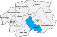
Okres Lučenec
| Overview maps | |
|---|---|

|

|
| Basic data Okres Lučenec | |
| Kraj : | Banskobystrický kraj |
| Area : | 825.59 km² |
| Residents : | 73,342 (December 31, 2019) |
| Population density : | 88.79 inhabitants / km² |
| License plate : | LC |
| District code: | 606 |
| Administrative division | |
| Cities: | 2 |
| Municipalities (excluding cities): | 55 |
| Statistics information about the Okres on statistics.sk | |
The Okres Lučenec (German district license ) is an administrative unit in central Slovakia with 73,342 inhabitants (December 31, 2019, 2001 there were 72,837, of which 49,266 (67.6%) Slovak, 20,072 (27.6%) Hungarian) and an area of 825.6 km².
Historically, the district is mostly in the former Nógrád county , a small part in the southeast around the towns of Šíd , Čamovce and Šurice belongs to the former Gemer and Kleinhont county (see also the list of historical counties in Hungary ).
In 2002 the communities Nové Hony and Pinciná were assigned to the Okres; before they were part of the Okres Poltár .
Cities
Communities
The district office is in Lučenec , a branch in Fiľakovo .
Culture
In the article Protected Objects in the Okres Lučenec you can find information about the objects in the Okres that are protected by the Slovak Monuments Office.